
Pricing Change
New pricing for orders of material from this site will come into place shortly. Charges for supply of digital images, digitisation on demand, prints and licensing will be altered.
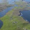
West Burra, Brough


Broch (Iron Age)(Possible)
Site Name West Burra, Brough
Classification Broch (Iron Age)(Possible)
Alternative Name(s) Southerhouse
Canmore ID 666
Site Number HU33SE 7
NGR HU 3789 3494
Datum OSGB36 - NGR
Permalink http://canmore.org.uk/site/666


- Council Shetland Islands
- Parish Lerwick
- Former Region Shetland Islands Area
- Former District Shetland
- Former County Shetland
HU33SE 7 3789 3494
( HU 3788 3497 ) Brough (O.E.) (Site of)
OS 6" map, Shetland, 2nd ed. (1903)
A rugged, grass-grown hillock, in a commanding position, the site of a broch.
Although no characteristic features are discernible, there are slight indications of regularly laid stone-work here and there, particularly in the neighbourhood of the cottage which encroaches on the site. The pier at Scalloway is said to have been built with stones from this broch. (Anderson 1873).
RCAHMS 1946, visited 1930
As described; no further information.
Visited by OS(AA) 15 May 1968
See also HU33SE 43
Putative broch site to the south of croft; the croft buildings encroach on a large grassed mound some 2.5m high.
J W Hedges 1984
M108 (site G1).
Field Visit (26 July 1930)
Broch, Brough. This structure is today represented only by a rugged grass-grown hillock, in a commanding position, close to the E margin of the public road at the N end of the small township of Brough. Although no characteristic features are discernible, there are slight indications of regularly laid stone-work here and there, particularly in the neighbourhood of the cottage which encroaches on the site. It is reported that the stones from this broch were ‘taken to build the pier at Scalloway’*.
RCAHMS 1946, visited 26 July 1930.
OS 6" map, Shetland, 2nd ed. (1903)
*Arch. Scot., v, p. 182, where the broch is wrongly placed in Tingwall parish.
Publication Account (2002)
HU33 1 WEST BURRA ('Brough')
HU/379350
Possible broch on the island of West Burra in Lerwick -- a rugged grass-grown hillock in a commanding position. There are slight indications of regularly laid stonework.
Sources: 1. OS card HU 33 SE 7: 2. RCAHMS 1946, vol. 3, no. 1277, 77: 3. Arch. Scot. 5, 182.
E W MacKie

