 |
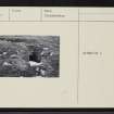
On-line Digital Images |
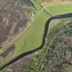
DP 080125 |
RCAHMS Aerial Photography Digital |
Oblique aerial view of the remains of the township buildings and rig, and the site of the excavations, taken from the WSW. |
29/5/2009 |
Item Level |
|
 |
On-line Digital Images |
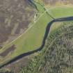
DP 080126 |
RCAHMS Aerial Photography Digital |
Oblique aerial view of the remains of the township buildings and rig, and the site of the excavations, taken from the SW. |
29/5/2009 |
Item Level |
|
 |
On-line Digital Images |
SC 1541589 |
Records of the Ordnance Survey, Southampton, Hampshire, England |
OS '495' card |
31/5/1961 |
Item Level |
|
 |
On-line Digital Images |
SC 2349826 |
Records of the Ordnance Survey, Southampton, Hampshire, England |
Suisgill, NC82NE 11, Ordnance Survey index card, page number 1, Recto |
1958 |
Item Level |
|
 |
On-line Digital Images |
SC 2349827 |
Records of the Ordnance Survey, Southampton, Hampshire, England |
Suisgill, NC82NE 11, Ordnance Survey index card, Recto |
1958 |
Item Level |
|
 |
On-line Digital Images |
SC 2349828 |
Records of the Ordnance Survey, Southampton, Hampshire, England |
Suisgill, NC82NE 11, Ordnance Survey index card, Recto |
1958 |
Item Level |
|


