Pricing Change
New pricing for orders of material from this site will come into place shortly. Charges for supply of digital images, digitisation on demand, prints and licensing will be altered.
Park Hill, Hillhead
Building (Post Medieval), Enclosure (Prehistoric), Fort (Prehistoric), Ring Ditch House(S) (Prehistoric)
Site Name Park Hill, Hillhead
Classification Building (Post Medieval), Enclosure (Prehistoric), Fort (Prehistoric), Ring Ditch House(S) (Prehistoric)
Alternative Name(s) Parks; Parkhill
Canmore ID 66355
Site Number NY09NE 2
NGR NY 06149 97490
Datum OSGB36 - NGR
Permalink http://canmore.org.uk/site/66355
- Council Dumfries And Galloway
- Parish Kirkpatrick-juxta
- Former Region Dumfries And Galloway
- Former District Annandale And Eskdale
- Former County Dumfries-shire
NY09NE 2 0613 9749.
(NY 0613 9749) Camp (NR)
OS 6" map, (1957).
An oval fort with a rampart at most 2' high, with indications of stone-work on the crest, and with a 15' wide trench, partially cut through rock, on the S side. It measures 238' by 195' transversely.
A hollow way extends some 90' from the N to pass through the W defences into the centre of the area, flanked on its N side by a wall which appears to have made a return southwards.
A break at the S end appears original; a gap in the E is probably secondary.
RCAHMS 1920; R W Feachem 1956.
A fort, generally as described.
Resurveyed at 1:2500.
Visited by OS (R D) 27 March 1972.
No change to previous field report.
Surveyed at 1:10,000.
Sketch plan & section.
Visited by OS (J R L) 8 September 1978.
Measured Survey (13 March 1991)
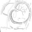
RCAHMS surveyed the fort at Park Hill on 13 March 1991 with plane-table and self-reducing alidade at a scale of 1:500. The plan was redrawn in ink and published at a scale of 1:1000 (RCAHMS 1997, Fig. 59).
Field Visit (13 March 1991)
NY 0613 9749 NY09NE 2
The poorly-preserved remains of this fort are situated on the more westerly of the two flat-topped summits of Park Hill. It comprises two main components: a roughly kidney-shaped fort; and a large outer enclosure.
The fort measures about 75m from NE to SW by up to 61m transversely within a stony rampart 4m thick and 0.7m high. On the S and SW the rampart is accompanied by an external ditch (2.4m broad and 0.6m deep) which, on the SW, is flanked by a low conterscarp bank. There are original entrances on the NW and SSE, while a third gap in the rampart, on the ENE, is of more recent date.
Within the interior, which incorporates several natural rises and bears traces of modern cultivation, there are at least three house-stances. One is the remains of a ring-ditch house measuring about 9m in diameter over a ditch up to 2.8m broad and 0.2m deep. It is best preserved on the N, and there is an entrance on the E. Adjacent to this on the NNE, there is a well-defined house-platform which measures about 6m in diameter. Traces of a second ring-ditch structure are visible about 15m W of this; it measures about 7m in diameter over a ditch 2.3m broad and 0.2m deep. Situated between the latter two houses, there are several low arcing scarps which probably indicate the presence of further house-sites.
A length of low stony bank extends from the N side of the NW entrance towards the centre of the fort and is of unknown function.
The outer enclosure is defined by a bank and external ditch where best preserved (on the S); elsewhere the bank has been reduced to a scarp or a scatter of stones and nothing is visible of the ditch. Basically oval on plan but with a bulbous extension on the W, it measures about 107m in diameter from NNE to SSW by up to 104m internally; the bank is up to 3m thick and 0.4m high and the ditch up to 2.5m broad and 0.3m deep. There is an entrance on the SSW. The enclosure does not appear to have fulfilled any defensive function, as the line of the bank does not follow any significant crests of slopes, preferring to traverse midslope on the N and E and the bottom of a wet hollow on the SE.
The remains of a small rectangular building, measuring about 7.5m from E to W by 4.6m transversely over stone wall-footings partly overlie the bank of the enclosure some 14m E of the entrance on the S.
Visited by RCAHMS (SMF), 13 March 1991.
Listed as fort , overlain by building.
RCAHMS 1997.
Note (28 May 2014 - 16 August 2016)
This fort is situated on the western of the flat-topped summits of Park Hill, and stands within what is either an annexe or an earlier enclosure. The fort is kidney-shaped on plan, and measures about 75m from NE to SW by up to 61m transversely (0.4ha) within a stony rampart up to 4m in thickness and 0.7m in height. Additional protection is provided on the S and SW by an external ditch 2.4m broad and 0.6m deep and a low conterscarp bank. Original entrances can be seen on the NW and SSE, the former exploiting a natural gully in the topography which forms a deep re-entrant in this side, while a gap in the rampart on the ENE is of more recent date. There are traces of modern cultivation within the interior, but at least two round-house platforms and two ring-ditch houses are still visible in the NE half.
The outer enclosure or annexe takes in an area of about 0.9ha, and where best preserved to either side of an entrance on the SSW is bounded by a low bank some 3m in thickness by 0.4m in height and an external ditch 2.5m broad and 0.3m deep; elsewhere this has been reduced to little more than a low scarp or a scatter of stones. The enclosure does not appear to be defensive as such, and the line of its perimeter tends to lie midslope or on the SE at the bottom of the bottom of a wet hollow. The footings of a small rectangular building overlie the bank to the E of the entrance
Information from An Atlas of Hillforts of Great Britain and Ireland – 16 August 2016. Atlas of Hillforts SC0884


