
Lag's Tomb


Cropmark(S) (Period Unknown), Promontory Fort (Period Unassigned), Rectilinear Enclosure (Period Unassigned)
Site Name Lag's Tomb
Classification Cropmark(S) (Period Unknown), Promontory Fort (Period Unassigned), Rectilinear Enclosure (Period Unassigned)
Canmore ID 65960
Site Number NX98SW 9
NGR NX 92836 83174
Datum OSGB36 - NGR
Permalink http://canmore.org.uk/site/65960


- Council Dumfries And Galloway
- Parish Dunscore
- Former Region Dumfries And Galloway
- Former District Nithsdale
- Former County Dumfries-shire
NX98SW 9 9276 8324.
(Approx: NX 9276 8324) Promontory fort? Parch marks on AP.
Visited by J K St Joseph 4 November 1949.
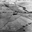
There are traces of a broad, shallow immeasurable hollow, probably natural, occurring where the wide curved parch mark appears on the AP's. There are no surface indications of the other marks. The hollow cuts off a promontory to the east, but the natural slopes are quite gentle. Visited by OS (RDL) 25 June 1964
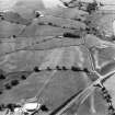
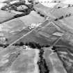
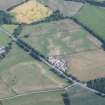
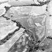
Enclosure and cropmarks visible on air photographs.
Further aerial photographs taken in 1978 (two enclosures and cropmarks noted).
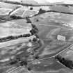
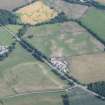
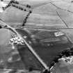
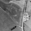
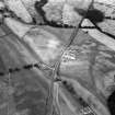
Rectangular enclosure on a slope near a probable Dark Age religious enclosure, now occupied by Dunscore Old Kirkyard and Lag's Tomb, down to the Glasgow Road. One of the enclosures is double-ditched and is similar to that at Carronbridge. A sub-rectangular enclosure and a large circular enclosure lie nearby.
A E Truckell 1984
Aerial Photographic Transcription (8 May 2012)
Note (14 February 2017 - 7 April 2017)
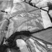
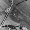
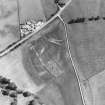
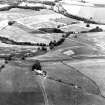
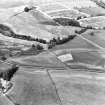
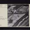
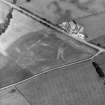
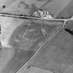
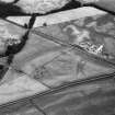
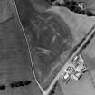
This ploughed-out fort occupies a triangular promontory formed in the leading edge of a terrace on the W of the River Nith some 150m ESE of the site of the old parish church of Dunscore, better known for the tomb of Sir Robert Grierson of Lag (d 1733). The flanks of the promontory are not particularly steep and a visit by the OS revealed that the ditch drawn in an arc across the level approach on the WNW coincided with a broad natural hollow. In addition to the ditch, which is up to 4m in breadth, traces of a concentric palisade trench can be detected in the cropmarks about 5m outside the outer lip of the ditch, while at least one other palisade trench can be seen in the interior, drawn in a roughly concentric arc about 12m within the inner lip; other faint marking may represent other lines of palisade both within and without the ditch. The triangular interior probably measures about 85m from WNW to ESE by 50m transversely (0.33ha). Towards the S the ditch appears to taper and turn along the flank of the promontory, and a minor ditch no more than 2m board returns across the ENE tip, though whether these two elements are related is unknown. At the NE end of the main ditch, however, the CUCAP images appear to show a rounded terminal, possibly indicating the position of an entrance opening onto the terrace on the NW along the NE margin of the promontory.
Information from An Atlas of Hillforts of Great Britain and Ireland – 07 April 2017. Atlas of Hillforts SC4379

