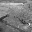
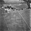
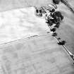
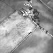
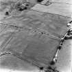
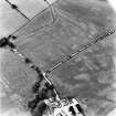
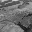
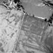
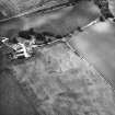
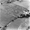
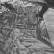
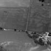
Enclosure (Period Unassigned)
Site Name Dalswinton
Classification Enclosure (Period Unassigned)
Alternative Name(s) Bankhead Farm
Canmore ID 65921
Site Number NX98SW 36
NGR NX 93413 84808
Datum OSGB36 - NGR
Permalink http://canmore.org.uk/site/65921
Ordnance Survey licence number AC0000807262. All rights reserved.
Canmore Disclaimer.
© Copyright and database right 2024.
- Correction
- Favourite
SC 1758730
Oblique aerial view of Dalswinton, Bankhead, taken from the SW, centred on the cropmarks of Roman Forts. An enclosure, situated to the SW of the the forts, is visible in bottom right-hand side of the photograph.
RCAHMS Aerial Photography
21/7/1997
© Crown Copyright: HES
SC 1758732
Oblique aerial view of Dalswinton, Bankhead, taken from the ESE, centred on the cropmarks of Roman forts. An enclosure, situated to the SE of the forts, is visible in the centre left of the photograph.
RCAHMS Aerial Photography
21/7/1997
© Crown Copyright: HES
SC 503755
Bankhead, Dalswinton, oblique aerial view, taken from the SSW, centred on the cropmarks of Roman Forts and showing an oval enclosure in the centre right of the photograph..
© RCAHMS
SC 2469347
Dalswinton, NX98SW 36, Ordnance Survey index card, Recto
Records of the Ordnance Survey, Southampton, Hampshire, England
1958
© Crown Copyright: HES (Ordnance Survey Archaeology Division Collection)
SC 1758611
Bankhead, Dalswinton, oblique aerial view, taken from the NE, centred on the cropmarks of Roman Forts and an oval enclosure.
RCAHMS Aerial Photography
7/8/1995
© Crown Copyright: HES
SC 1758616
Bankhead, Dalswinton, oblique aerial view, taken from the NW, centred on the cropmarks of Roman Forts and an oval enclosure.
RCAHMS Aerial Photography
7/8/1995
© Crown Copyright: HES
SC 1758742
Oblique aerial view of Dalswinton, Bankhead, taken from the NE, centred on the cropmarks of Roman forts. An enclosure, situated to the SE, is visible in the centre left of the photograph. A linear cropmark, situated to the SW of the forts, is visible inthe top centre of the photograph.
RCAHMS Aerial Photography
21/7/1997
© Crown Copyright: HES
SC 1758744
Oblique aerial view of Dalswinton, Bankhead, taken from the NW, centred on the cropmarks of Roman forts. An enclosure, situated to the SE, is visible in the top right-hand side of the photograph.
RCAHMS Aerial Photography
21/7/1997
© Crown Copyright: HES
SC 1758746
Oblique aerial view of Dalswinton, Bankhead, taken from the SW, centred on the cropmarks of Roman forts. An enclosure, situated to the SE, is visible in the bottom right-hand side of the photograph.
RCAHMS Aerial Photography
21/7/1997
© Crown Copyright: HES
SC 2469348
Dalswinton, NX98SW 36, Ordnance Survey index card, Recto
Records of the Ordnance Survey, Southampton, Hampshire, England
1958
© Crown Copyright: HES (Ordnance Survey Archaeology Division Collection)
SC 1758608
Bankhead, Dalswinton, oblique aerial view, taken from the SSW, centred on the cropmarks of Roman Forts and showing an oval enclosure in the centre right of the photograph..
RCAHMS Aerial Photography
10/7/1995
© Crown Copyright: HES
SC 1758613
Bankhead, Dalswinton, oblique aerial view, taken from the NNE, centred on the cropmarks of Roman Forts and an oval enclosure.
RCAHMS Aerial Photography
7/8/1995
© Crown Copyright: HES
SC 1758615
Bankhead, Dalswinton, oblique aerial view, taken from the NNW, centred on the cropmarks of Roman Forts and an oval enclosure.
RCAHMS Aerial Photography
7/8/1995
© Crown Copyright: HES
SC 1758726
Oblique aerial view of Dalswinton, Bankhead, taken from the W, centred on the cropmarks of Roman forts. An enclosure, situated to the SE of the forts, is visible in the centre right of the photograph.
RCAHMS Aerial Photography
21/7/1997
© Crown Copyright: HES
SC 1758745
Oblique aerial view of Dalswinton, Bankhead, taken from the W, centred on the cropmarks of Roman forts. An enclosure, situated to the SE, is visible in the centre right of the photograph.
RCAHMS Aerial Photography
21/7/1997
© Crown Copyright: HES
SC 2469349
Dalswinton, NX98SW 36, Ordnance Survey index card, Recto
Records of the Ordnance Survey, Southampton, Hampshire, England
1958
© Crown Copyright: HES (Ordnance Survey Archaeology Division Collection)
SC 1758728
Oblique aerial view of Dalswinton, Bankhead, taken from the SSW, centred on the cropmarks of Roman forts. An enclosure, situated to the SE of the forts, is visible in the bottom left-hand side of the photograph.
RCAHMS Aerial Photography
21/7/1997
© Crown Copyright: HES
SC 1758741
Oblique aerial view of Dalswinton, Bankhead, taken from the SE, centred on the cropmarks of Roman forts. An enclosure, situated to the SE, is visible in the bottom left-hand side of the photograph.
RCAHMS Aerial Photography
21/7/1997
© Crown Copyright: HES
SC 1758605
Bankhead, Dalswinton, oblique aerial view, taken from the S, centred on the cropmarks of Roman Forts and an oval enclosure.
RCAHMS Aerial Photography
10/7/1995
© Crown Copyright: HES
SC 1758607
Bankhead, Dalswinton, oblique aerial view, taken from the WNW, centred on the cropmarks of Roman Forts and showing an oval enclosure in the centre right of the photograph..
RCAHMS Aerial Photography
10/7/1995
© Crown Copyright: HES
SC 1758621
Bankhead, Dalswinton, oblique aerial view, taken from the S, centred on the cropmarks of Roman Forts and an oval enclosure.
RCAHMS Aerial Photography
7/8/1995
© Crown Copyright: HES
SC 1758731
Oblique aerial view of Dalswinton, Bankhead, taken from the SE, centred on the cropmarks of Roman forts. An enclosure, situated to the SE of the forts, is visible in the bottom right-hand side of the photograph.
RCAHMS Aerial Photography
21/7/1997
© Crown Copyright: HES
SC 1758733
Oblique aerial view of Dalswinton, Bankhead, taken from the NE, centred on a linear cropmark. An enclosure situated to the SW of the cropmark, is visible in the bottom left-hand corner of the photograph.
RCAHMS Aerial Photography
21/7/1997
© Crown Copyright: HES
SC 1758614
Bankhead, Dalswinton, oblique aerial view, taken from the N, centred on the cropmarks of Roman Forts and an oval enclosure.
RCAHMS Aerial Photography
7/8/1995
© Crown Copyright: HES
SC 1758618
Bankhead, Dalswinton, oblique aerial view, taken from the WNW, centred on the cropmarks of Roman Forts and an oval enclosure.
RCAHMS Aerial Photography
7/8/1995
© Crown Copyright: HES
SC 1758606
Bankhead, Dalswinton, oblique aerial view, taken from the NNE, centred on the cropmarks of Roman Forts and an oval enclosure.
RCAHMS Aerial Photography
10/7/1995
© Crown Copyright: HES
SC 1758622
Bankhead, Dalswinton, oblique aerial view, taken from the ESE, centred on the cropmarks of Roman Forts and an oval enclosure.
RCAHMS Aerial Photography
7/8/1995
© Crown Copyright: HES
SC 1758724
Oblique aerial view of Dalswinton, Bankhead, taken from the N, centred on the cropmarks of Roman forts. An enclosure, situated to the SE of the forts, is visible in the top left-hand side of the photograph.
RCAHMS Aerial Photography
21/7/1997
© Crown Copyright: HES
SC 1758725
Oblique aerial view of Dalswinton, Bankhead, taken from the NW, centred on the cropmarks of Roman forts. An enclosure, situated to the SE of the forts, is visible in the top right-hand side of the photograph.
RCAHMS Aerial Photography
21/7/1997
© Crown Copyright: HES
SC 1758729
Oblique aerial view of Dalswinton, Bankhead, taken from the S, centred on the cropmarks of Roman forts. An enclosure, situated to the SW of the forts, is visible in the bottom left-hand side of the photograph.
RCAHMS Aerial Photography
21/7/1997
© Crown Copyright: HES
SC 1758740
Oblique aerial view of Dalswinton, Bankhead, taken from the SSE, centred on the cropmarks of Roman forts. An enclosure, situated to the SE, is visible in the bottom right-hand side of the photograph.
RCAHMS Aerial Photography
21/7/1997
© Crown Copyright: HES
SC 1758743
Oblique aerial view of Dalswinton, Bankhead, taken from the NNW, centred on the cropmarks of Roman forts. An enclosure, situated to the SE, is visible in the centre of the photograph.
RCAHMS Aerial Photography
21/10/1997
© Crown Copyright: HES
- Council Dumfries And Galloway
- Parish Kirkmahoe
- Former Region Dumfries And Galloway
- Former District Nithsdale
- Former County Dumfries-shire
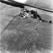
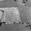
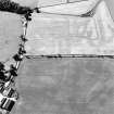
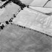
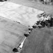
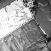
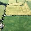
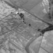
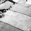
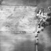
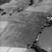
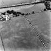
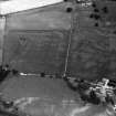
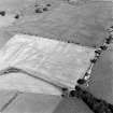
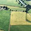
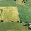
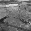
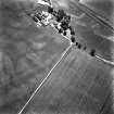
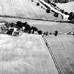
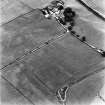
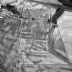
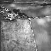
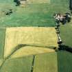
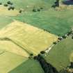
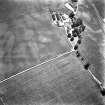
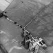
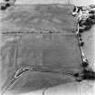
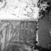
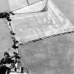
NX98SW 36 934 848.
Small roughly circular ditched enclosure just north of Bankhead farm.
A E Truckell 1984
Aerial Photographic Transcription (29 May 2012)