
Dalswinton, Bankfoot


Pit(S) (Roman), Roman Fort (Roman)
Site Name Dalswinton, Bankfoot
Classification Pit(S) (Roman), Roman Fort (Roman)
Alternative Name(s) Bankfoot 2
Canmore ID 65920
Site Number NX98SW 35
NGR NX 93301 84101
NGR Description Centred NX 9330 8410
Datum OSGB36 - NGR
Permalink http://canmore.org.uk/site/65920


- Council Dumfries And Galloway
- Parish Kirkmahoe
- Former Region Dumfries And Galloway
- Former District Nithsdale
- Former County Dumfries-shire
NX98SW 35 933 841
See also NX98SW 10.
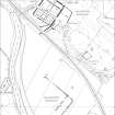
NX933 841. A large Roman fort with two periods of occupation was discovered at Dalswinton in 1972, close to the site of the known Flavian fort (NX98SW 10).
A length of some 725ft of the SE side, the rounded east angle and 400 ft of the NE side has been recorded. There were two broad ditches and the alignment of the SE side differed by some 225ft in the two phases. The outer set of ditches is interrupted about the mid-point of the visible length at a gate with a titulum. A length of only 250ft of the corresponding inner pair of ditches is visible so that the position of the SE gate in that phase remains undetermined.
This fort lies on the level floodplain of the Nith, and the ditches on the SE side disappear at the edge of a hollow marking an old river channel, so that river erosion may have destroyed the SW defences of the fort. That the present course of the river lies a little to the west of its position in the Roman age is shown by the fact that the camp at Ellisland (NX98SW 6) on the opposite bank has lost its east angle to river erosion.
As to date it may be observed that the fort lies within a large temporary camp (NX98SW 12) of which the only known gate has an external clavicula. Moreover, the SE side of this camp just overlaps part of a much smaller camp ( ?) of Stracathro type.
At the already known fort (NX98SW 10) situated in a much more commanding position on high ground 500 ft to the north, excavations here have shown that both periods of occupation are Flavian in date. The position of the new fort on the floodplain strongly suggests that it is earlier than the other, but presumably also Flavian, though a sequence of four successive Flavian phases in permanent works was hitherto unknown in Scotland.
J K St Joseph 1973
(NX 933 839) Possible fort rampart visible on air photographs (RAF/541/A 397/3248-9)
(Undated) information in NMRS.
Photographed by the RCAHM.
(Undated) information in NMRS.
N angle recognised 1984, allowing re-calculation of area at about 8.7 ha, and possible re-interpretation as 'vexillation fortress' of Agricolan date.
G S Maxwell and D R Wilson 1987
Magnetometry (June 2009)
NX 934 840 and NX 9330 8410 Magnetic survey in three fields S of the railway line at Dalswinton Bankfoot undertaken in June 2009 revealed the northern part of the western side of the large Roman camp (NX98SW 12). Numerous anomalies within the interior may represent the remains of field ovens. Part of the double ditch of the presumed Roman fort (NX98SW 35) was also detected, but it contained no clear internal structures, suggesting that this site may have been temporary.
Archive: RCAHMS (intended)
Funder: Deutsches Archäologisches Institut
C-M Hüssen, Rebecca Jones, WS Hanson – Römisch-Germanische Kommission (RGK)/RCAHMS/Glasgow University Archaeology Department
Aerial Photographic Transcription (18 May 2012 - 24 May 2012)

