
Pricing Change
New pricing for orders of material from this site will come into place shortly. Charges for supply of digital images, digitisation on demand, prints and licensing will be altered.
Upcoming Maintenance
Please be advised that this website will undergo scheduled maintenance on the following dates:
Thursday, 9 January: 11:00 AM - 3:00 PM
Thursday, 23 January: 11:00 AM - 3:00 PM
Thursday, 30 January: 11:00 AM - 3:00 PM
During these times, some functionality such as image purchasing may be temporarily unavailable. We apologise for any inconvenience this may cause.
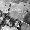
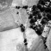
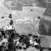
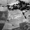
Carzield


Enclosure (Period Unassigned)
Site Name Carzield
Classification Enclosure (Period Unassigned)
Canmore ID 65858
Site Number NX98SE 49
NGR NX 97021 81944
Datum OSGB36 - NGR
Permalink http://canmore.org.uk/site/65858


- Council Dumfries And Galloway
- Parish Kirkmahoe
- Former Region Dumfries And Galloway
- Former District Nithsdale
- Former County Dumfries-shire
Aerial Photographic Transcription (7 June 2012)
This enclosure has been recorded as a cropmark on oblique aerial photographs (RCAHMSAP 1983). It is circular in plan and defined by a ditch about 3.65m wide, but only the E section is visible. The enclosed area is about 60m in diameter. There is also a short section of external palisade ditch 21m long and 1.2m wide outside the main ditch, at the SE.
Information from RCAHMS (KHJM) 7 June 2012

