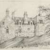
Cowhill Tower
Tower House (Medieval)
Site Name Cowhill Tower
Classification Tower House (Medieval)
Canmore ID 65835
Site Number NX98SE 3
NGR NX 95146 82529
Datum OSGB36 - NGR
Permalink http://canmore.org.uk/site/65835
- Council Dumfries And Galloway
- Parish Holywood
- Former Region Dumfries And Galloway
- Former District Nithsdale
- Former County Dumfries-shire
NX98SE 3 95146 82529.
(NX 9514 8253) Cowhill Tower (NR) (Remains of)
OS 6" map (1946)
The ruins of this L-shaped dwelling consist solely of the east wall of the longer wing. On the door lintel is the date 1597.
RCAHMS 1920, visited 1912
Cowhill Tower was built in 1579 as the old castle had been burnt in 1560. A few weeks after the view was drawn in 1789, demolition was begun.
F Grose 1789
Cowhill Tower was burnt down by the returning Jacobites after the '45.
Trans Dumfriesshire Galloway Natur Hist Antiq Soc 1924
The remains consist of the east wall of the longer wing and a fragment of the walls of the shorter wing. The walls are c 0.6m thick with a maximum height of c 4.0m. The east wall is c 7.6m long with the remains of a small turret at its north end. The date on the door lintel is 1579.
Surveyed at 25"
Visited by OS (WDJ) 29 June 1964


