|
Prints and Drawings |
SUD 104/9 S |
Dr Joanna Close-Brooks |
Location map Dr. J. Close-Brooks 1980 Slide only |
1980 |
Item Level |
|
|
Photographs and Off-line Digital Images |
SU 597 |
Dr Joanna Close-Brooks |
Excavation Dr. J Close-Brooks |
1977 |
Item Level |
|
|
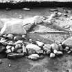
Photographs and Off-line Digital Images |
SU 598 |
Dr Joanna Close-Brooks |
Excavation Dr. J Close-Brooks |
1977 |
Item Level |
|
|
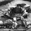
Photographs and Off-line Digital Images |
SU 599 |
Dr Joanna Close-Brooks |
Excavation Dr. J Close-Brooks |
1977 |
Item Level |
|
|
Prints and Drawings |
SUD 103/1 |
Dr Joanna Close-Brooks |
Plans and section excavation pencil 1:20 Close-Brooks 197 7 GOLSPIE |
|
Item Level |
|
|
Prints and Drawings |
SUD 103/2 |
Dr Joanna Close-Brooks |
Plans and section excavation pencil 1:20 Close-Brooks 197 7 GOLSPIE |
|
Item Level |
|
|
Prints and Drawings |
SUD 103/3 |
Dr Joanna Close-Brooks |
Plans and section excavation pencil 1:20 Close-Brooks 197 7 GOLSPIE |
|
Item Level |
|
 |
On-line Digital Images |
SC 1924405 |
Dr Joanna Close-Brooks |
Excavation Dr. J Close-Brooks |
1977 |
Item Level |
|
 |
On-line Digital Images |
SC 1924406 |
Dr Joanna Close-Brooks |
Excavation Dr. J Close-Brooks |
1977 |
Item Level |
|
 |
On-line Digital Images |
SC 2349695 |
Records of the Ordnance Survey, Southampton, Hampshire, England |
Dairy Park, Dunrobin, NC80SW 17, Ordnance Survey index card, page number 1, Recto |
c. 1958 |
Item Level |
|
 |
On-line Digital Images |
SC 2349696 |
Records of the Ordnance Survey, Southampton, Hampshire, England |
Dairy Park, Dunrobin, NC80SW 17, Ordnance Survey index card, Recto |
c. 1958 |
Item Level |
|
|
All Other |
551 281/5 |
Dr Joanna Close-Brooks |
Archive from excavations at Dairy Park, Dunrobin |
1977 |
Sub-Group Level |
|


