
New Abbey, Sweetheart Abbey, Wall


Monastic Precinct (Period Unassigned), Wall (Period Unassigned)
Site Name New Abbey, Sweetheart Abbey, Wall
Classification Monastic Precinct (Period Unassigned), Wall (Period Unassigned)
Canmore ID 65465
Site Number NX96NE 9.01
NGR NX 9655 6635
Datum OSGB36 - NGR
Permalink http://canmore.org.uk/site/65465


- Council Dumfries And Galloway
- Parish New Abbey
- Former Region Dumfries And Galloway
- Former District Nithsdale
- Former County Kirkcudbrightshire
NX96NE 9.01 9655 6635
(Name: NX 9655 6635) Abbey Wall (NR)
OS 6" map (1971)
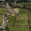
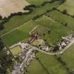
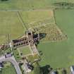
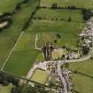
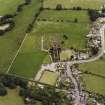
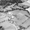
A massive stone wall surrounded the Abbey precinct, an area of 30 acres. It still remains in a fair state of preservation on the N and W sides, varying in height from 3 ft to 12 ft, and with a thickness of about 4 ft, being built of rough granite boulders averaging 4 ft in diameter. The E side is reduced almost to the foundations. No traces of a wall exist to the S, but this side is said to have been bounded by a water-filled ditch, indications of which were found in 1877 when work was in progress in connection with the parish church. A pillar, of late date, attached to a modern building on the S side of the road where it passes through the W wall may indicate the locality of the W entrance. All traces of the E gateway have been destroyed.
RCAHMS 1914, visited 1911; J S Richardson 1951
The precinct wall still stands on the W and N at a maximum height of 4.0 m. On the E side it is much lower and between St Mary's R C Chapel and the school a modern wall has been built on its foundations. The course of the water-filled ditch on the S side of the precinct can be traced vaguely along the base of a hedge between NX 9627 6613 and NX 9660 6600, but on the N side of the hedge between NX 9632 6609 and NX 9638 6605, a definite scarp, 0.4 m high, probably indicated the inner face of the ditch.
Earthwork surveyed at 1:2500.
Visited by OS (WDJ) 6 April 1964
NX 966 660 A series of large granite boulders were disturbed during garden works in November 1994 at NX 9661 6603, to the W side of the A710. They probably represent the S side of the Abbey precinct wall. Record photographs are held in Dumfries and Galloway SMR.
Sponsor: Dumfries and Galloway Regional Council.
J Brann 1995.
NX 962 662 A watching brief was carried out during 1997 and 1998 on the construction of a new sewage pumping station near the North Bridge, New Abbey, and associated sewers through the village. The programme of works included some disturbance of the Scheduled area adjacent to the Corn Mill, thought to be on or near the site of the monastic mill, and further E the new sewers extended some 70m within the abbey precinct.
A clay-bonded granite-built footing for the N pier of the W gateway of the abbey precinct was encountered beneath the southbound carriageway of the A710, demonstrating the gateway to have been approximately 5.2m wide.
The SE corner of a substantial structure, with walls in excess of 1m thick built of granite, was encountered below the grass verge of the southbound carriageway of the A710, 15m NNE of the existing Corn Mill. The interior of the structure lies beneath the modern road and was not exposed. No dating evidence for it was found, but its position adjacent to the New Abbey Pow makes it a candidate for the monastic mill.
Sponsor: West of Scotland Water Authority.
M L Brann 1998.
Watching Brief (5 June 2013 - 10 October 2013)
A programme of archaeological monitoring was carried out in support of the demolition of an existing extension and the erection of a new larger extension at 32 Main Street, New Abbey. No archaeologically significant deposits were uncovered during the course of this work and no anthropic material was recovered other than that which related to the modern (late 20th or 21st century) use of the site.
Alan Matthews and Katie Sludden (Rathmell Archaeology) 28 November 2013; OASIS-ID: rathmell1-152323

