
Pricing Change
New pricing for orders of material from this site will come into place shortly. Charges for supply of digital images, digitisation on demand, prints and licensing will be altered.
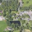
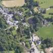
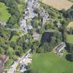
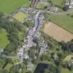
New Abbey, Abbey House And Garden Walls


Monastic Dwelling (17th Century), Wall(S) (Period Unassigned)
Site Name New Abbey, Abbey House And Garden Walls
Classification Monastic Dwelling (17th Century), Wall(S) (Period Unassigned)
Alternative Name(s) Old Abbey House
Canmore ID 65437
Site Number NX96NE 32
NGR NX 96257 66206
Datum OSGB36 - NGR
Permalink http://canmore.org.uk/site/65437


- Council Dumfries And Galloway
- Parish New Abbey
- Former Region Dumfries And Galloway
- Former District Nithsdale
- Former County Kirkcudbrightshire
NX96NE 96257 66206.
(NX 9625 6620) Old Abbey House (NAT)
OS 25" map (1966)
Abbey House: 17th century house (with early origin), home of the last abbot of New Abbey (NX96NE 9); two storeys with moulded door and window surrounds.
SDD List 1967
Photographic Survey (October 1962)
Photographic survey of buildings in New Abbey, Kirkcudbrightshire, by the Scottish National Buildings Records in October 1962.

