
Mainsriddle


Building (Period Unassigned)(Possible)
Site Name Mainsriddle
Classification Building (Period Unassigned)(Possible)
Canmore ID 65346
Site Number NX95NE 16
NGR NX 95184 56827
Datum OSGB36 - NGR
Permalink http://canmore.org.uk/site/65346


- Council Dumfries And Galloway
- Parish Kirkbean
- Former Region Dumfries And Galloway
- Former District Nithsdale
- Former County Kirkcudbrightshire
Aerial Photographic Transcription (23 March 2012)
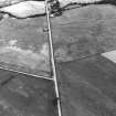
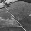
What may be a sub-rectangular building is visible as cropmarking on an oblique aerial photograph. It measures about 13m from ENE to WSW by perhaps 6m transversely within a narrow trench less than 1m across. The SSE side is straight, but the two ends appear to be bowed, while the N side is rather indistinct. The long axis of the possible building lies parallel to the road.
Information from RCAHMS (DCC) 8 September 2014

