
Drumlanrig


Field Boundary (Period Unassigned), Pit Alignment (Roman), Temporary Camp (Roman)
Site Name Drumlanrig
Classification Field Boundary (Period Unassigned), Pit Alignment (Roman), Temporary Camp (Roman)
Alternative Name(s) Drumlanrig Castle Policies
Canmore ID 65205
Site Number NX89NE 66
NGR NX 85721 98841
Datum OSGB36 - NGR
Permalink http://canmore.org.uk/site/65205


- Council Dumfries And Galloway
- Parish Durisdeer
- Former Region Dumfries And Galloway
- Former District Nithsdale
- Former County Dumfries-shire
NX89NE 66 8572 9884
For Drumlanrig Castle (NX 85190 99214), policies and associated buildings, see NX89NE 1.00.
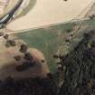
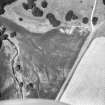
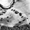
Aerial photography has revealed a small Roman temporary camp a short distance S of the fort described on NX89NE 61. (Information from G S Maxwell).
S S Frere 1985.
Aerial reconnaissance in 1997 has revealed more of the temporary camp known to the SE of the Roman fort. The whole of the NW side, the N angle and part of the NE and SW sides are now known, suggesting that the camp's dimensions are at least 150m by 120m.
Information from RCAHMS (RHM) 31 March 1998
Publication Account (17 December 2011)
Three camps are known close to Drumlanrig, on the River Nith, with two farther south on the east side of the river (Carronbridge and possibly Waterside Mains). Only parts of the two camps immediately south of the fort are known, with the camp at Islafoot lying across the river. The fort and camps I and II lie in the grounds of Drumlanrig Castle; because most of the area is in parkland, it is possible that more wait to be found. The fort is suspected to have Flavian origins (Maxwell and Wilson 1987: 19–20) and is known to have Antonine phases (Hunter 2005: 401–2; see above, Chapter 6).
Both the fort and camps were discovered in 1984 by RCAHMS as cropmarks from the air (Frere 1985a: 267). Camps I and II lie on a low terrace close to the river. Camp I measures about 105m from north-east to south-west by about 87m enclosing almost 1ha (2.4 acres). A titulus is visible in its north-west side. Camp II lies immediately west of this camp, and measures 229m by 159m, enclosing almost 3.5ha (8.6 acres). No entrances are known. The two camps may intersect one another, or camp I could represent an annexe to its larger neighbour.
A series of pits are visible running in a line parallel to and outside the south-west side of camp II . They have a slightly irregular appearance and may be the remains of ovens (see above, section 7f ).
R H Jones
Aerial Photographic Transcription (24 April 2012)

