
Drumlanrig Roman Fort


Roman Fort (Roman)
Site Name Drumlanrig Roman Fort
Classification Roman Fort (Roman)
Alternative Name(s) River Nith; Drumlanrig Castle Policies; Drumlanrig, Roman Fort And Annexe 400m Se Of Drumlanrig Castle
Canmore ID 65200
Site Number NX89NE 61
NGR NX 85426 98906
Datum OSGB36 - NGR
Permalink http://canmore.org.uk/site/65200


- Council Dumfries And Galloway
- Parish Durisdeer
- Former Region Dumfries And Galloway
- Former District Nithsdale
- Former County Dumfries-shire
NX89NE 61 854 989
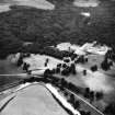
For Drumlanrig Castle (NX 85190 99214), policies and associated buildings, see NX89NE 1.00.
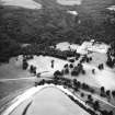
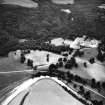
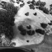
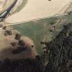
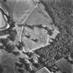
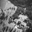
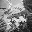
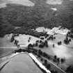
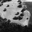
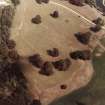
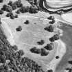
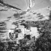
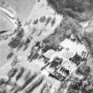
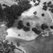
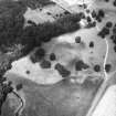
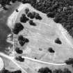
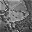
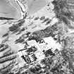
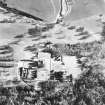
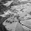
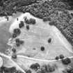
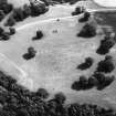
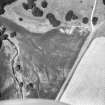
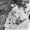
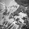
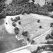
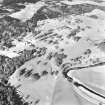
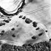
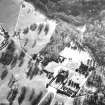
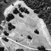
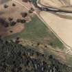
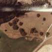
Aerial survey has revealed the parch-marks of a Roman fort c.350m SE of Drumlanrig Castle (NX89NE 1/00) on the right bank of the Nith. Over the ramparts it measures c.150m N-S by 100m (an area of 1.5ha = 3.7 acres) and is still traceable on the surface; a complex ditch-system, incorporating annexes on the S and E, was recorded.
The street-pattern suggests that the barracks may not have been of standard length and that part of the garrison may have been outposted as at Crawford (NS92SE 2).
The position of the fort shows that the Roman road crossed the river in this sector. A 2nd-century bronze paters recorded from Auchenskeoch
(NS80SW 4) probably originated from this fort. (Information from G S Maxwell.)
S S Frere 1985; The Scotsman 22 July 1985
Presumed Flavian date on account of 'parrot's beak' ditch terminal at S entrance.
G S Maxwell and D R Wilson 1987.
Project (2004)
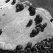
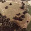
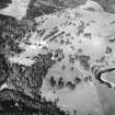
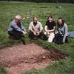
Aerial photographs taken during the hot summer of 1984 provided some spectacular results, including a series of cropmarks that suggested the presence of a previously unknown Roman fort. These cropmarks had never been archaeologically investigated. Geophysical survey and limited excavation were undertaken in order to establish the nature and extent of the archaeological remains, as well as to provide an assessment of their degree of preservation.
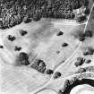
The site of the Roman fort covers just over 3 acres (1.2ha), measuring c 150 x 100m, and follows the traditional 'playing card' plan. It is situated on the summit of a level plateau on the left bank of the Marr Burn, not far from its confluence with the River Nith. It is defended by a single rampart which is still visible as a low broad bank on the edge of the plateau, and approximately four or five ditches. Beyond these, to the S and E, are further ditches, which may indicate the presence of an annexe. Two known Roman marching camps lie nearby, on opposing sides of the River Nith, which was probably forded close to the fort.
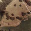
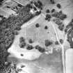
A gradiometer survey provided a clearer picture of the fort than that established from the parchmark evidence. Buildings within the fort could be outlined with a 'typical' fort layout. The principia could be identified towards the southern central part of the fort. Ditches surrounding the fort forming the defences could also be clearly outlined following the norm of a playing card shape. Within the eastern half of the data, outside of the fort, anomalies with an archaeological response could indicate a vicus or annexe.
The resistance data were comparable with the gradiometer results. The streets were clearly defined by bands of high resistance. Buildings present in the gradiometer data showed as undefined areas of high resistance with no form, suggesting that the responses are from rubble spreads from the former military structures.
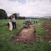
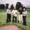
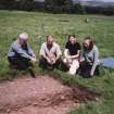
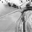
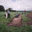
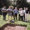
A total of 12 trenches were opened in various different locations within the fort or across its ramparts. These were targeted on specific features identified from the geophysical survey, including the ramparts, the NW gateway, the location of a possible corner tower, and the presumed headquarters building. All the trenches contained archaeological deposits, features or finds.
The evaluation revealed a complex palimpsest of deposits across the site. The trench excavated across the ramparts showed a single phase of defences, comprising a deep V-shaped ditch with a partly turf-constructed rampart. Material recovered from the ditch includes Black Burnished ware pottery dated to the Antonine period.
Pottery recovered from both stratified and unstratified deposits all points to an Antonine date for the construction and use of the fort. The small quantity of pottery recovered includes sherds of Dorset BB1, Central Gaulish Samian and South Spanish amphora. The archaeological remains in the trenches included stone footings for the headquarters building, metalled road surfaces, in situ surfaces and slots for timber sill beams. In some cases more than one phase of construction was evident within a trench. Within the limited areas excavated, however, it was not possible to establish whether there was an earlier phase of fort construction. The absence of any strong evidence for more than one phase of defences, along with the dearth of any Flavian material, even as residual artefacts in later contexts, suggests that there was no pre-Antonine phase on the site. It was not possible within the restrictions of the project to investigate any of the remains in the area of the possible annexe, and the possibility of an earlier complex cannot be dismissed.
The excavations established that the fort was probably deliberately slighted on abandonment, with strong evidence for burning in many of the trenches within the interior of the fort. Evidence from the headquarters building indicates that some of the stone foundations were also robbed out. There is little evidence for the use of the fort beyond the Antonine period, suggesting that it had a fairly limited lifespan. Its size and layout indicate that it was probably built to house an auxiliary unit, possibly comprising a mixed detachment of infantry and cavalry. Part of the auxiliary regiment may have been stationed in nearby fortlets. No significant post-Roman deposits or features were identified during the project. Although the site appears to have been subject to some ploughing in the past, in general the archaeological remains were well preserved.
Sponsor: Videotext Communications Ltd.
C Gibson 2004.
Earth Resistance Survey (2004)
Resistance survey.
Sponsor: Videotext Communications Ltd.
C Gibson 2004.
Magnetometry (2004)
Magnetometry survey.
Sponsor: Videotext Communications Ltd.
C Gibson 2004.
Aerial Photographic Transcription (24 April 2012)

