
Carronbridge


Settlement (Period Unassigned)
Site Name Carronbridge
Classification Settlement (Period Unassigned)
Canmore ID 65158
Site Number NX89NE 24
NGR NX 87149 97690
Datum OSGB36 - NGR
Permalink http://canmore.org.uk/site/65158


- Council Dumfries And Galloway
- Parish Morton
- Former Region Dumfries And Galloway
- Former District Nithsdale
- Former County Dumfries-shire
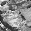
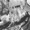
NX89NE 24 8716 9767.
(NX 8719 9765) The parch mark of part of a roughly circular enclosure is visible on air photograph.
There is no trace of any feature at the site, which occupies low ground overlooked by a slope to the E and NE.
There is no surface evidence of this crop mark which falls in regularly cultivated land.
Visited by OS (TRG) 19 December 1977
Homestead, Carronbridge: visible on air photographs.
Aerial Photographic Transcription (23 April 2012 - 24 April 2012)

