
Pricing Change
New pricing for orders of material from this site will come into place shortly. Charges for supply of digital images, digitisation on demand, prints and licensing will be altered.
Carrol


Structure (Period Unassigned)
Site Name Carrol
Classification Structure (Period Unassigned)
Canmore ID 6505
Site Number NC80NW 3
NGR NC 8471 0647
Datum OSGB36 - NGR
Permalink http://canmore.org.uk/site/6505


- Council Highland
- Parish Clyne
- Former Region Highland
- Former District Sutherland
- Former County Sutherland
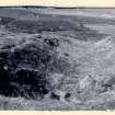
NC80NW 3 8471 0647.
Some 80 yards to the SE of Carrol Broch (NC80NW 1) "a shallow weem-like structure, 8ft in diameter at top, and with well-built wall, occurs in the face of the terrace, and from this a deep trench runs northwards for about 30 yards. Some animal bones were found here, and two chert scrapers."
J M Joass 1873.
The weem-like structure and trench are still visible although the walling is almost obscured by grass. The trench running NE from it is still apparent and is also visible running towards the bank of the Allt Coire Aghaisgeig on the SW.
RCAHMS 1911, visited 1909.
NC 8473 0648.This structure is a cup-shaped hollow 2.8m in diameter and 0.8m deep. The hollow is walled with stone and opens out into a trench or gully on its NE side. The trench, as described by RCAHMS, is 6.0m wide and 1.0m deep. The purpose of this structure was not ascertained.
Visited by OS (W D J) 24 April 1964.
No change since report of 24 April 1964.
Visited by OS (J B) 3 November 1975.

