 |
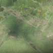
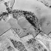
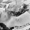
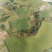
On-line Digital Images |
DP 278070 |
Historic Environment Scotland |
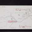
Oblique aerial view. |
16/5/2018 |
Item Level |
|
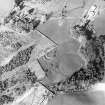 |
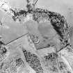
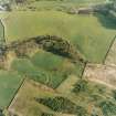
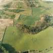
On-line Digital Images |
SC 1757312 |
RCAHMS Aerial Photography |
Oblique aerial view centred on the remains of the homestead, taken from the SW. |
1/5/2000 |
Item Level |
|
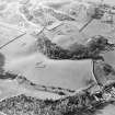 |
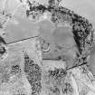
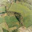
On-line Digital Images |
SC 1757313 |
RCAHMS Aerial Photography |
Oblique aerial view centred on the remains of the homesteads, taken from the SE. |
1/5/2000 |
Item Level |
|
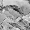 |
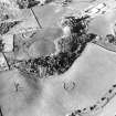
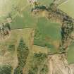
On-line Digital Images |
SC 1757314 |
RCAHMS Aerial Photography |
Oblique aerial view centred on the remains of the homesteads, taken from the NW. |
1/5/2000 |
Item Level |
|
 |
On-line Digital Images |
SC 1757315 |
RCAHMS Aerial Photography |
Oblique aerial view centred on the remains of the homesteads, taken from the NW. |
1/5/2000 |
Item Level |
|
 |
On-line Digital Images |
SC 1757316 |
RCAHMS Aerial Photography |
Oblique aerial view centred on the remains of the homestead, taken from the WNW. |
1/5/2000 |
Item Level |
|
 |
On-line Digital Images |
SC 1757317 |
RCAHMS Aerial Photography |
Oblique aerial view centred on the remains of the homestead, taken from the WNW. |
1/5/2000 |
Item Level |
|
 |
On-line Digital Images |
SC 1757320 |
RCAHMS Aerial Photography |
Oblique aerial view centred on the remains of the homesteads, taken from the SSW. |
1/5/2000 |
Item Level |
|
 |
On-line Digital Images |
SC 1757321 |
RCAHMS Aerial Photography |
Oblique aerial view centred on the remains of the homesteads, taken from the S. |
1/5/2000 |
Item Level |
|
 |
On-line Digital Images |
SC 1757340 |
RCAHMS Aerial Photography |
Oblique aerial view centred on the remains of the homesteads, taken from the NNW. |
1/5/2000 |
Item Level |
|
 |
On-line Digital Images |
SC 1757341 |
RCAHMS Aerial Photography |
Oblique aerial view centred on the remains of the homesteads, taken from the WNW. |
1/5/2000 |
Item Level |
|
 |
On-line Digital Images |
SC 1757342 |
RCAHMS Aerial Photography |
Oblique aerial view centred on the remains of the homestead, taken from the W. |
1/5/2000 |
Item Level |
|
 |
On-line Digital Images |
SC 1757343 |
RCAHMS Aerial Photography |
Oblique aerial view centred on the remains of the homesteads, taken from the SW. |
1/5/2000 |
Item Level |
|
 |
On-line Digital Images |
SC 1757344 |
RCAHMS Aerial Photography |
Oblique aerial view centred on the remains of the homesteads, taken from the S. |
1/5/2000 |
Item Level |
|
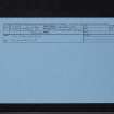 |
On-line Digital Images |
SC 2467695 |
Records of the Ordnance Survey, Southampton, Hampshire, England |
Mcnaughton's Fort, NX87NE 3, Ordnance Survey index card, Recto |
c. 1958 |
Item Level |
|
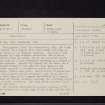 |
On-line Digital Images |
SC 2467696 |
Records of the Ordnance Survey, Southampton, Hampshire, England |
Mcnaughton's Fort, NX87NE 3, Ordnance Survey index card, page number 1, Recto |
c. 1958 |
Item Level |
|
 |
On-line Digital Images |
SC 2467697 |
Records of the Ordnance Survey, Southampton, Hampshire, England |
Mcnaughton's Fort, NX87NE 3, Ordnance Survey index card, page number 2, Verso |
c. 1958 |
Item Level |
|
 |
On-line Digital Images |
SC 2467698 |
Records of the Ordnance Survey, Southampton, Hampshire, England |
Mcnaughton's Fort, NX87NE 3, Ordnance Survey index card, page number 3, Recto |
c. 1958 |
Item Level |
|
 |
On-line Digital Images |
SC 2467699 |
Records of the Ordnance Survey, Southampton, Hampshire, England |
Mcnaughton's Fort, NX87NE 3, Ordnance Survey index card, Recto |
c. 1958 |
Item Level |
|
 |
On-line Digital Images |
SC 2740409 |
Records of the Ordnance Survey, Southampton, Hampshire, England |
NX87NE 3 and 5, Ordnance Survey index card, Recto |
c. 1958 |
Item Level |
|
|
All Other |
551 166/1/1 |
Records of the Ordnance Survey, Southampton, Hampshire, England |
Archaeological site card index ('495' cards) |
1947 |
Sub-Group Level |
|


