 |
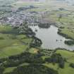
On-line Digital Images |
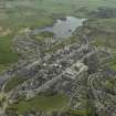
DP 030634 |
RCAHMS Aerial Photography Digital |
General oblique aerial view of the town with Carlingwark Loch beyond, taken from the NNW. |
27/4/2007 |
Item Level |
|
 |
On-line Digital Images |
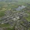
DP 030635 |
RCAHMS Aerial Photography Digital |
General oblique aerial view of the town with Carlingwark Loch beyond, taken from the NW. |
27/4/2007 |
Item Level |
|
 |
On-line Digital Images |
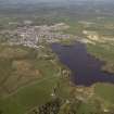
DP 030638 |
RCAHMS Aerial Photography Digital |
General oblique aerial view of the town with Carlingwark Loch in the foreground, taken from the SW. |
27/4/2007 |
Item Level |
|
 |
On-line Digital Images |
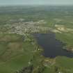
DP 030639 |
RCAHMS Aerial Photography Digital |
General oblique aerial view of the town with Carlingwark Loch in the foreground, taken from the SW. |
27/4/2007 |
Item Level |
|
 |
On-line Digital Images |
DP 090755 |
RCAHMS Aerial Photography Digital |
General oblique aerial view looking over Caringwark Loch towards Castle Douglas, taken from the SW. |
6/7/2010 |
Item Level |
|
 |
On-line Digital Images |
SC 2466894 |
Records of the Ordnance Survey, Southampton, Hampshire, England |
Carlingwark Loch, NX76SE 8, Ordnance Survey index card, Recto |
c. 1958 |
Item Level |
|
 |
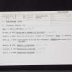
On-line Digital Images |
SC 2466895 |
Records of the Ordnance Survey, Southampton, Hampshire, England |
Carlingwark Loch, NX76SE 8, Ordnance Survey index card, Recto |
c. 1958 |
Item Level |
|
 |
On-line Digital Images |
SC 2466896 |
Records of the Ordnance Survey, Southampton, Hampshire, England |
Carlingwark Loch, NX76SE 8, Ordnance Survey index card, Verso |
c. 1958 |
Item Level |
|
 |
On-line Digital Images |
SC 2466897 |
Records of the Ordnance Survey, Southampton, Hampshire, England |
Carlingwark Loch, NX76SE 8, Ordnance Survey index card, Recto |
c. 1958 |
Item Level |
|


