
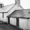
Crossmichael Mill


Grain Mill (Period Unassigned)
Site Name Crossmichael Mill
Classification Grain Mill (Period Unassigned)
Canmore ID 64603
Site Number NX76NW 23
NGR NX 73961 67563
Datum OSGB36 - NGR
Permalink http://canmore.org.uk/site/64603


- Council Dumfries And Galloway
- Parish Crossmichael
- Former Region Dumfries And Galloway
- Former District Stewartry
- Former County Kirkcudbrightshire
Field Walking (7 October 2010 - 31 October 2010)
In October 2010, North Pennines Archaeology Ltd was commissioned by Edwin Thompson Chartered Surveyors, to undertake an archaeological desk-based assessment and walkover survey of Craig Hill, Langholm, Dumfries and Galloway (NGR NY 330 882).
The survey area is located within the vicinity of a number of features, including two Scheduled Ancient Monuments on Craig Hill and Little Hill, and prehistoric burnt mounds. There are also records of an old field bank adjacent to the road as well as the yet unconfirmed route of the Roman Road on the eastern slope of Craig Hill. In the 1980s the RCAHMS surveyed the area, however they were selective in what was recorded.
The archaeological walkover survey recorded 14 sites, 11 of which were identified from early cartographic sources, one site that was recorded during a 2007 archaeological walkover survey, and two previously unrecorded sites.
Information from Oasis (northpen3-84718) 26 March 2013

