
Pricing Change
New pricing for orders of material from this site will come into place shortly. Charges for supply of digital images, digitisation on demand, prints and licensing will be altered.
Glennap Fort


Fort (Period Unassigned)
Site Name Glennap Fort
Classification Fort (Period Unassigned)
Canmore ID 64410
Site Number NX74NW 14
NGR NX 7272 4510
Datum OSGB36 - NGR
Permalink http://canmore.org.uk/site/64410


- Council Dumfries And Galloway
- Parish Rerrick
- Former Region Dumfries And Galloway
- Former District Stewartry
- Former County Kirkcudbrightshire
NX74NW 14 7272 4510.
(NX 7272 4510) Glennap Fort (NR)
OS 6" map (1957)
Fort.
RCAHMS 1914; F R Coles 1891
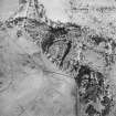
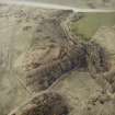
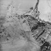
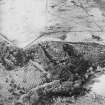
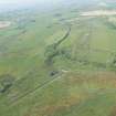
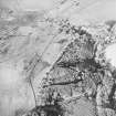
Glennap Fort (name confirmed), situated on a thickly overgrown knoll beside a stream, measures internally 81.0m NE-SW by 50.0m transversely. It consists of an earth-and-stone rampart in the N and elsewhere survives as a scarp except for a short section of bank in the S. Below this is a berm which becomes a ditch with counterscarp bank in the N. There are two gaps in the defences, that in the N is probably a modern mutilation while the one in the SW with its easy approach is probably the original entrance.
Surveyed at 1/2500.
Visited by OS (JP) 19 April 1971
Note (20 December 2013 - 4 August 2016)
This fort, which occupies a rounded hillock, is oval on plan and measures 81m from NE to SW by 50m transversely within an earthen rampart with an external rock-cut ditch. The rampart is best preserved on the N, elsewhere forming a scarp up to 3.5m in height above the bottom of the ditch, which for much of its circuit has been reduced to little more than a terrace some 3m broad, but on the N is flanked by a counterscarp bank. The defences at the southern end have been severely reduced by later cultivation, and the featureless interior has probably been cultivated also. A gap in the defences on the N is probably modern, but one on the SW is likely to be original, giving access from an easy line of approach.
Information from An Atlas of Hillforts of Great Britain and Ireland – 04 August 2016. Atlas of Hillforts SC0275

