
Fiscary


Cairn (Period Unassigned)
Site Name Fiscary
Classification Cairn (Period Unassigned)
Canmore ID 6437
Site Number NC76SW 4
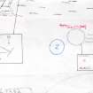
NGR NC 72857 62618
Datum OSGB36 - NGR
Permalink http://canmore.org.uk/site/6437


- Council Highland
- Parish Farr
- Former Region Highland
- Former District Sutherland
- Former County Sutherland
NC76SW 4 72857 62618
(NC 7285 6261) Cairn (NR)
OS 6"map, (1964)
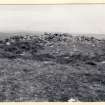
A cairn, measuring about 11m in diameter and 1.2m high.
RCAHMS 1911, visited 1909; Visited by OS (J L D) 13 June 1960
This cairn is as described.
Surveyed at 1:2500 scale (Visited by OS {R L} 8 July 1971).
Visited by OS (N K B) 14 July 1977.
A round cairn with large boulders, situated on the crest of a hill and measuring 10m in diameter and 1.3m high.
R J Mercer 1981.

