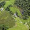
Earlstoun Castle
Castle (Medieval)
Site Name Earlstoun Castle
Classification Castle (Medieval)
Alternative Name(s) Earlston Castle
Canmore ID 64287
Site Number NX68SW 1
NGR NX 61268 84022
Datum OSGB36 - NGR
Permalink http://canmore.org.uk/site/64287
- Council Dumfries And Galloway
- Parish Dalry (Stewartry)
- Former Region Dumfries And Galloway
- Former District Stewartry
- Former County Kirkcudbrightshire
NX68SW 1 61268 84022.
(NX 6126 8402) Earlstoun Castle (NR).
OS 6" map (1957)
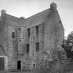
Earlstoun Castle (N Tranter 1965), now in a poor state of repair, is a typical laird's house of late 16th or early 17th century date. It is L-planned, with a main block of three storeys and a garret; the rubble walls are 4ft thick and the gables are not crowstepped. Low extensions have been added at an early date to both gables and curtain walls have enclosed a courtyard, but little of these now remain. Some windows have been enlarged and altered, and beneath a first-floor window on the S side of the main block is a stone dated 1655; this is shown by MacGibbon and Ross (1889) on the E addition, now ruinous, to the erection of which the date apparently refers.
In the 16th century Earlstoun belonged to the Sinclairs, passing to the Gordons in the late 16th or early 17th century when this house would be erected, probably on the site of an earlier stronghold.
RCAHMS 1914, visited 1911
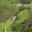
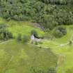
Earlstoun Castle (name verified by Capt Forbes, Earlstoun Lodge, Dalry), is unoccupied and is now part of a group of farm outbuildings. It is in a good state of repair externally and the 1655 datestone and the moulded window frames are well preserved. The "low extensions" are visible as turf-covered footings and parts of the curtain wall are still evident. Surveyed at 1:2500.
Visited by OS (TRG) 16 February 1978
The castle has now fallen into a state of disrepair and the internal structures are in danger of giving way. The upper floors have collapsed, leaving walls wthout proper lateral ties. The owners now wish to stabilise the structure and reinstate the missing floors. Before this work took place, GUARD undertook a standing building recording.
The castle is an L-shaped tower house, built in greywacke rubble with sandstone dressings. The dressings sit proud of the rubble masonry, suggesting that the building was originally harled. The smaller wing of the castle comprises a turnpike stair and turret stair and two rooms. The principal wing has three stories and an attic. The interior walls are of rubble masonry and between 0.6m and 1.2m thick. The ground floor is barrel-vaulted and has two rooms. The first floor runs the entire length of the wing. This was the main hall and has 4 window openings, which have been enlarged at some point. There are still the remains of finely-carved woodwork, including panelling, rails, skirting and a cornice. The interior panelling and design was changed on a number of occasions, including around 1660. The second floor is accessed through the turret stair through a panelled passageway, since destroyed. This floor is divided into two rooms by a timber-panelled partition. There has been much alteration work, including the windows, which have been enlarged. Another window has been filled in with rubble masonry. This floor has remnants of wooden panelling and a plasterwork ceiling. The attic is accessed through the turret stair. A wall in the attic was heightened by 0.45m in order to facilitate the fastening of pendant posts to stabilise the rafters. No flooring in the attic has survived.
C Francoz 2005
Watching Brief (7 March 2011 - 17 March 2011)
GUARD Archaeology Limited were commissioned by ARP Lorimer to undertake an archaeological watching brief during the installation of services at Earlstoun Castle, St John's Town of Dalry, Dumfries and Galloway (NGR: NX 61268 84022). The work was undertaken between the 7th and 17th March 2011 and revealed no features or artefacts of archaeological significance.
Archive: RCAHMS and WoSAS
Funder: ARPL Architects Ltd
GUARD Archaeology Ltd 2011
Information also reported in Oasis (guardarc1-100643) 15 November 2012
Note
In the 16th century Earlstoun belonged to the Sinclairs, passing to the Gordons in the early 17th century, around which time the house was erected, probably on the site of an earlier stronghold. The Gordons sold the estate in the early 1740s, after which the castle was no longer used for lairdly accommodation. The New Statistical Account reported in 1845 that 'With some repair it might be made habitable'. This appears to have been done, as some 50 years later MacGibbon and Ross stated that there were 'people not yet old, who were born in the house'.
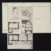
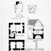
Earlstoun Castle is a late 16th/early 17th century L-plan tower-house, with a main block of three storeys and a garret. The stair wing contains the entrance, from which there is access to the barrel vaulted ground-floor chambers, and also the spiral stair leading to the first floor. The upper floors of the main block and the wing are reached by a smaller stair corbelled out externally in the re-entrant angle. The walls, which are relatively thin, are of greywacke rubble with sandstone dressings and the gables have flat skews. There is no evidence that the tower ever had a parapet, and it has no gunloops.
The tower shows evidence of extensive structural alterations, including the windows, which have been enlarged in the main block. These alterations date from the late 17th century, when the interior was reordered. The original fireplace in the first-floor hall was partly built up and partly converted into a window, and the walls of the hall were wainscotted, with fluted pilasters and dentilled cornices, elements of which still survive. The second floor was divided into two rooms by a timber-panelled partition and they were accessed by way of a panelled passageway from the stair, since destroyed.
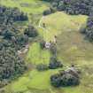
The castle sits within a group of farm buildings which, although relatively modern in appearance, may contain older fabric. A one-and-a-half storey wing was added to the east gable of the tower sometime before 1655 and now survives as a single wall and grass covered footings. An inscribed marriage stone dated 1655 and with the initials W G and M H for William Gordon and his wife Mary Hope was built into the wing and is now located; under one of the first floor windows of the tower. The wing, which communicated with the tower through slappings at ground and first-floor level, housed a new kitchen and appears to have returned to the south to create a U-shaped complex of buildings.
J Gifford 1996; D MacGibbon and T Ross 1887; A M T Maxwell-Irving 2000; RCAHMS
Information from the HES Castle Conservation Register, 5 July 2022


