
Pricing Change
New pricing for orders of material from this site will come into place shortly. Charges for supply of digital images, digitisation on demand, prints and licensing will be altered.
Upcoming Maintenance
Please be advised that this website will undergo scheduled maintenance on the following dates:
Thursday, 9 January: 11:00 AM - 3:00 PM
Thursday, 23 January: 11:00 AM - 3:00 PM
Thursday, 30 January: 11:00 AM - 3:00 PM
During these times, some functionality such as image purchasing may be temporarily unavailable. We apologise for any inconvenience this may cause.
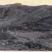
An Rath Chruineach


Cairnfield (Period Unassigned), Hut Circle (Prehistoric), Souterrain (Prehistoric)(Possible)
Site Name An Rath Chruineach
Classification Cairnfield (Period Unassigned), Hut Circle (Prehistoric), Souterrain (Prehistoric)(Possible)
Canmore ID 6426
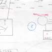
Site Number NC76SW 3
NGR NC 7269 6282
Datum OSGB36 - NGR
Permalink http://canmore.org.uk/site/6426


- Council Highland
- Parish Farr
- Former Region Highland
- Former District Sutherland
- Former County Sutherland
NC76SW 3 7269 6282.
(NC 7269 6282) An Rath Chruineach (NAT) Enclosure (NR)
OS 6"map, (1964)
A hut circle. A 'tunnel' is said to have been discovered in an adjacent field many years ago.
RCAHMS 1911, visited 1909.
An oval stone-walled hut circle about 9.0m N-S by 8.0m transversely within a wall spread to 2.5m. It has been mutilated on the NW, NE and SW by the erection of fences. The entrance is in the south. Extending westwards and north-eastwards from the hut are a few stone clearance heaps probably from contemporary cultivation plots. The name could not be confirmed. The 'tunnel', possibly a souterrain, was not located.
Hut surveyed at 1:2500 scale.
Visited by OS (J L D) 27 April 1960, (R L) 12 July 1971 and (N K B) 14 July 1977.

