|
Photographs and Off-line Digital Images |
KB 1362 |
List C Survey |
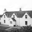
View of rear of farmhouse from NE. |
1975 |
Item Level |
|
|
Photographs and Off-line Digital Images |
KB 1361 |
List C Survey |
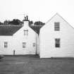
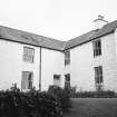
View of farmhouse from S. |
1975 |
Item Level |
|
|
Photographs and Off-line Digital Images |
KB 1363 |
List C Survey |
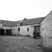
General view of steading. |
1975 |
Item Level |
|
|
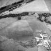
Photographs and Off-line Digital Images |
D 57293 |
RCAHMS Aerial Photography |
Oblique aerial view centred on the farmsteading, taken from the SW. |
24/8/1999 |
Item Level |
|
|
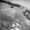
Photographs and Off-line Digital Images |
D 57294 |
RCAHMS Aerial Photography |
Oblique aerial view centred on the farmsteading, taken from the SSW. |
24/8/1999 |
Item Level |
|
 |
On-line Digital Images |
SC 1633567 |
List C Survey |
View of farmhouse from S. |
1975 |
Item Level |
|
 |
On-line Digital Images |
SC 1633568 |
List C Survey |
View of rear of farmhouse from NE. |
1975 |
Item Level |
|
 |
On-line Digital Images |
SC 1633569 |
List C Survey |
General view of steading. |
1975 |
Item Level |
|
 |
On-line Digital Images |
SC 1633961 |
List C Survey |
View of rear of farmhouse from NE. |
1975 |
Item Level |
|
 |
On-line Digital Images |
SC 1671251 |
RCAHMS Aerial Photography |
Oblique aerial view centred on the farmsteading, taken from the SW. |
24/8/1999 |
Item Level |
|
 |
On-line Digital Images |
SC 1671252 |
RCAHMS Aerial Photography |
Oblique aerial view centred on the farmsteading, taken from the SSW. |
24/8/1999 |
Item Level |
|
 |
On-line Digital Images |
SC 2466030 |
Records of the Ordnance Survey, Southampton, Hampshire, England |
Flintloch, NX67NW 11, Ordnance Survey index card, Recto |
c. 1958 |
Item Level |
|


