
Pricing Change
New pricing for orders of material from this site will come into place shortly. Charges for supply of digital images, digitisation on demand, prints and licensing will be altered.
Cai Dun


Broch (Iron Age)(Possible)
Site Name Cai Dun
Classification Broch (Iron Age)(Possible)
Canmore ID 6413
Site Number NC76SW 18
NGR NC 71 61
Datum OSGB36 - NGR
Permalink http://canmore.org.uk/site/6413


- Council Highland
- Parish Farr
- Former Region Highland
- Former District Sutherland
- Former County Sutherland
NC76SW 18 71 61.
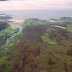
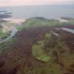
Cai Duin (Remains of) or Cai Dun, 'the house hill', is 'The remains of a pict's house so called from the elevated position it occupies' (ONB 1873). It is located to the area centred NC 71 61 but is not published on the OS 6"map, Sutherland, 1st ed., (1873) sheet 18.
Name Book 1873.
This structure was not located during field investigation.
Visited by OS (J L D) 28 April 1960.
Not located.
Visited by OS (R L) 7 July 1971.
Publication Account (2007)
NC76 2 CAI DUN
c. NC/71 61
Site of a possible broch in Farr, Sutherland; it wasmarked as a “Pict's house” on the OS map of 1873 but recent visits have failed to locate any structure [1].
Source: 1. NMRS site no. NC 76 SW 18:
E W MacKie 2007

