
Tongland Railway Viaduct


Railway Viaduct (19th Century)
Site Name Tongland Railway Viaduct
Classification Railway Viaduct (19th Century)
Alternative Name(s) Tongland Viaduct; River Dee
Canmore ID 64112
Site Number NX65SE 69
NGR NX 69269 53377
Datum OSGB36 - NGR
Permalink http://canmore.org.uk/site/64112


- Council Dumfries And Galloway
- Parish Tongland
- Former Region Dumfries And Galloway
- Former District Stewartry
- Former County Kirkcudbrightshire
NX65SE 69 69269 53377
For corresponding road bridge (adjacent to W), see NX65SE 63.
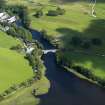
Tongland Railway Viaduct is depicted on Ordnance Survey GIS Epoch 4 map dating from 1922 to 1969. The NMRS List C Survey photograph (KB/1963) shows only the supporting piers standing. The railway viaduct spanned the River Dee which forms the boundary between the parishes of Kirkcudbright (to the S) and Tongland (to the N).
Information from RCAHMS (LKFJ), April 2002.
This viaduct formerly carried the Kirkcudbright branch (from Castle Douglas) of the former Glasgow and South Western Rly over the River Dee at the head of its estuary. It was presumably opened by the Kirkcudbright Rly on 7 March 1864, and closed to regular passenger traffic (with the line as a whole) on 3 May 1965.
Information from RCAHMS (RJCM), 17 March 2006.
G Daniels and L Dench 1980; R V J Butt 1995.
Watching Brief (1 February 2014 - 24 February 2014)
Built 1737. 2-arch stone bridge spanning River Dee on Tongland/Kirkcudbright parish boundaries. 2 segmental arches, 100ft approx span in all including central pier. V-cutwater buttresses flank arches to both elevations; possibly partially rebuilt or quoin-stones recut. Narrow rubble voussoirs, rubble soffit and abutments. Dressed stone to cutwaters and base of central pier. Rubble parapets rebuilt and now cantilevered out to give footpaths each side. Original width of carriageway 10ft approx. Parapet with sandstone coping and slightly splayed embrasures terminating in pyramidal capstone.
Information from Hannah Tweedie, CFA Archaeology Ltd., February 2014
Project (1 February 2014 - 24 February 2014)
An archaeological evaluation has been carried out by CFA Archaeology Ltd (CFA) using information provided by the Dumfries and Galloway Historic Environment Record (HER). A desk-based study was undertaken in order to assess the archaeological potential of the proposed development area. No intrusive site investigation work was undertaken during the assessment. A desk-based study was undertaken in order to assess the archaeological potential of the proposed development area. No intrusive site investigation work was undertaken during the assessment. Fifteen cultural heritage features have been identified within the study area. The construction works will involve the extension of the substation. No known cultural heritage features will be directly impacted by the proposed development works.
Information from Hannah Tweedie, CFA Archaeology Ltd., February 2014

