
Raeberry Castle


Castle (Medieval)
Site Name Raeberry Castle
Classification Castle (Medieval)
Canmore ID 63985
Site Number NX64SE 6
NGR NX 6991 4372
Datum OSGB36 - NGR
Permalink http://canmore.org.uk/site/63985


- Council Dumfries And Galloway
- Parish Kirkcudbright
- Former Region Dumfries And Galloway
- Former District Stewartry
- Former County Kirkcudbrightshire
NX64SE 6 6991 4372
(NX 6990 4373) Raeberry Castle (NR) (Site of).
OS 6" map (1957)
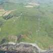
Raeberry Castle, the seat of the MacLellan family, stood upon a rock, overhanging steep cliffs, and cut off on the landward side by two deep ditches, and a strong wall. This wall, and the drawbridge, are supposed to have been destroyed about 90 years ago (ie c.1750), and the interior buildings about 200 years before that, though faint remnants of ramparts may still be seen at either end of the promontory.
F R Coles 1891; New Statsitical Account (NSA) 1845 (J McMillan)
No trace of Raeberry Castle remains; only the earthworks survive.
Revised at 25".
Visited by OS (RD) 16 April 1971
Raeberry Castle is sited on a narrow promontory of land jutting out to the sea to the W of the hill named Big Raeberry, which overlooks it. The castle itself probably stood at the seaward end of the promontory, where the ground rises into an oval stack, but little trace of it is now visible in the rank vegetation that blankets the interior. On the landward side, however, at least three ditches have been drawn across the neck of the promontory, the innermost tailored from a natural gully that flanks the N side of the stack. This forms a cutting about 15m broad and 4m deep, and a scatter of stones in cattle disturbance along its inner scarp is possibly the remains of a defensive wall. The outer ditches, which are separated by a rampart about 8m in thickness and 1m in height, are less imposing features, the inner of them 6m broad and 1.5m deep. The line of the outer is only marked by a scarp some 2m high where its outer lip has been cut back into the slope that drops into the neck of the promontory from the N. There is no trace of the original entrance, but a more recent trackway has been driven through the defences, crossing the innermost ditch on a rough causeway which may have been constructed to facilitate stone robbing from the walls of the castle. All that is now visible within the interior are a few shallow depressions and low mounds, perhaps marking the position of old excavation trenches.
(KTA02 8)
Visited by RCAHMS (DCC) 14 August 2002

