
Pricing Change
New pricing for orders of material from this site will come into place shortly. Charges for supply of digital images, digitisation on demand, prints and licensing will be altered.
Upcoming Maintenance
Please be advised that this website will undergo scheduled maintenance on the following dates:
Thursday, 9 January: 11:00 AM - 3:00 PM
Thursday, 23 January: 11:00 AM - 3:00 PM
Thursday, 30 January: 11:00 AM - 3:00 PM
During these times, some functionality such as image purchasing may be temporarily unavailable. We apologise for any inconvenience this may cause.
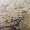
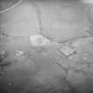
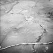
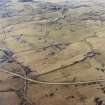
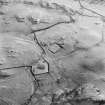
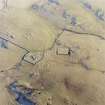
Dunrod Village


Rig And Furrow (Medieval) - (Post Medieval), Village (Period Unassigned)
Site Name Dunrod Village
Classification Rig And Furrow (Medieval) - (Post Medieval), Village (Period Unassigned)
Canmore ID 63929
Site Number NX64NE 9
NGR NX 6991 4598
Datum OSGB36 - NGR
Permalink http://canmore.org.uk/site/63929


- Council Dumfries And Galloway
- Parish Kirkcudbright
- Former Region Dumfries And Galloway
- Former District Stewartry
- Former County Kirkcudbrightshire
NX64NE 9 6991 4598.
(NX 6991 4598) Dunrod Village (NR) (Site of)
OS 6" map (1957)
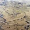
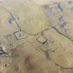
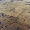
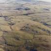
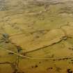
Nothing remains of the village of Dunrod which traditionally was populous and of considerable note. The church (NX64NE 8) (which is presumably contemporary) is in the middle of an extensive layout of ridge and furrow. According to the OS the village was depopulated at the time of the Civil Wars (c. 1650).
Name Book 1849; OSA 1795; C A R Radford 1963
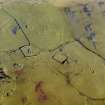
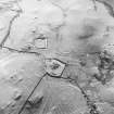
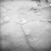
There are no surface indications of the village which was presumably centred around the moat and church.
Visited by OS (JP) 17 April 1971.
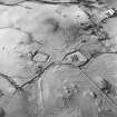
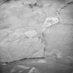
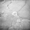
There are no remains of buildings at this location. The features described by Oram (2000, 256) are the ends of rigs.
There is an extensive system of unenclosed rig and furrow surviving across an area of about 88 hectares as earthworks up to 0.6m in height.
Visited by RCAHMS (DCC) 25 November 2002

