Accessibility

Font Size

100% 150% 200%

Background Colour

Default Contrast
Close Reset

Dunrod Church And Graveyard

Burial Ground (Medieval), Church (Medieval), Font (Medieval)

Site Name Dunrod Church And Graveyard

Classification Burial Ground (Medieval), Church (Medieval), Font (Medieval)

Canmore ID 63928

Site Number NX64NE 8

NGR NX 69950 46020

Datum OSGB36 - NGR

Permalink http://canmore.org.uk/site/63928

Ordnance Survey licence number AC0000807262. All rights reserved.
Canmore Disclaimer. © Bluesky International Limited 2025. Public Sector Viewing Terms

Toggle Aerial | View on large map

Digital Images

Oblique aerial view centred on the remains of rig with church, burial ground, homestead moat and building adjacent, taken from the ESE.
Oblique aerial view centred on the remains of rig with church, burial ground, homestead moat and building adjacent, taken from the ESE.Oblique aerial view centred on the remains of the church, burial ground, homestead moat and building with rig adjacent, taken from the E.Oblique aerial view centred on the remains of the church, burial ground, homestead moat and building with rig adjacent, taken from the WSW.Oblique aerial view centred on the remains of the church, burial ground, homestead moat and building with rig adjacent, taken from the WSW.Dunrod Church And Graveyard, NX64NE 8, Ordnance Survey index card, page number 1, RectoOblique aerial view centred on the remains of rig with church, burial ground, homestead moat and building adjacent, taken from the SE.Oblique aerial view centred on the remains of rig with church, burial ground, homestead moat and building adjacent, taken from the NW.Oblique aerial view centred on the remains of the church, burial ground, homestead moat and building with rig adjacent, taken from the NNW.Dunrod Church And Graveyard, NX64NE 8, Ordnance Survey index card, page number 1, RectoOblique aerial view centred on the remains of rig with church, burial ground, homestead moat and building adjacent, taken from the ESE.Oblique aerial view centred on the remains of the church, burial ground, homestead moat, building and enclosure with rig adjacent, taken from the WSW.Oblique aerial view centred on the remains of the church, burial ground, homestead moat, building and enclosure with rig adjacent, taken from the SE.Oblique aerial view centred on the remains of the church, burial ground, homestead moat, building and enclosure with rig adjacent, taken from the NNW.Oblique aerial view centred on the remains of rig with church, burial ground, homestead moat and building adjacent, taken from the ESE.Dunrod Church And Graveyard, NX64NE 8, Ordnance Survey index card, RectoDunrod Church And Graveyard, NX64NE 8, Ordnance Survey index card, page number 2, VersoOblique aerial view centred on the remains of the church, burial ground, homestead moat and building with rig adjacent, taken from the NNW.Dunrod Church And Graveyard, NX64NE 8, Ordnance Survey index card, page number 2, VersoOblique aerial view centred on the remains of the church, burial ground, homestead moat, building and enclosure with rig adjacent, taken from the SSW.Oblique aerial view centred on the remains of the church, burial ground, homestead moat, building and enclosure with rig adjacent, taken from the ENE.General view.Oblique aerial view centred on the remains of the church, burial ground, homestead moat and building with rig adjacent, taken from the WNW.

Administrative Areas

  • Council Dumfries And Galloway
  • Parish Kirkcudbright
  • Former Region Dumfries And Galloway
  • Former District Stewartry
  • Former County Kirkcudbrightshire

Archaeology Notes

NX64NE 8 69950 46020.

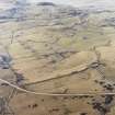
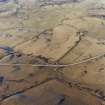
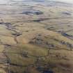
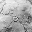
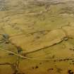
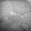
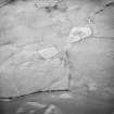
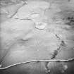
(NX 6995 4602) Dunrod Church (NR) (Remains of)

OS 6" map (1957)

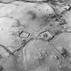
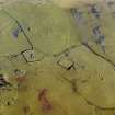
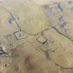
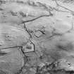
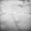
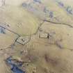
Dunrod church, now ruinous, was dedicated to St Mary and St Brioc, and attached to Holyrood Abbey. On plan, the ruins are of the simple Norman type, with a nave and chancel measuring 30' 2" by 18' 9", and 18' by 14' 4" respectively, within c. 3' 4" thick walls, which now stand only 3' above ground. It appears at one time to have stood within an enclosure, now almost levelled, measuring 76' 2" by 42' 2". The present boundary wall enclosing the graveyard is probably of 19th century date.

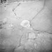
The interior of the ruined church is filled with modern tombstones and vegetation. Its elaborate Romanesque font is in Kirkcudbright Museum. The parish was united to Kirkcudbright c. 1663.

RCAHMS 1914, visited 1911; C A R Radford 1963; H Scott 1917; 1950

The remains of the church are as described. Part of the enclosing wall survives in the SW.

Revised at 1/2500.

Visited by OS (DWR) 7 April 1971.

References

MyCanmore Image Contributions


Contribute an Image

MyCanmore Text Contributions