
Doonhill


Settlement (Period Unassigned)
Site Name Doonhill
Classification Settlement (Period Unassigned)
Canmore ID 63239
Site Number NX44NW 7
NGR NX 4144 4704
Datum OSGB36 - NGR
Permalink http://canmore.org.uk/site/63239


- Council Dumfries And Galloway
- Parish Sorbie
- Former Region Dumfries And Galloway
- Former District Wigtown
- Former County Wigtownshire
NX44NW 7 4144 4704.
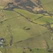
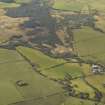
(NX 4144 4704) Earthwork (NR)
OS 6" map (1957)
Fort, Doon Hill.
RCAHMS 1912, visited 1911
An earthwork set just below the highest point of Doon Hill, on a slope facing SW, and much reduced by cultivation. It consists of two earthen ramparts with a medial ditch, measuring some 44m E-W by 34m transversely from centre to centre of the inner rampart. No entrance is visible, but it may have been placed in the NW side, now levelled by the plough. The interior is featureless.
The dimensions and form of the earthwork, together with its situation on sloping ground, place it in a class common in SW Scotland which, despite the lack of internal structures, is probably a settlement.
Resurveyed at 1:2500.
Visited by OS (WDJ) 24 August 1970

