 |
On-line Digital Images |
SC 446252 |
Papers of Professor John R Hume, economic and industrial historian, Glasgow, Scotland |
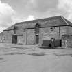
Garlieston, Harbour
View from NW showing mill, granary and pier |
26/8/1974 |
Item Level |
|
 |
On-line Digital Images |
SC 446254 |
Papers of Professor John R Hume, economic and industrial historian, Glasgow, Scotland |
Garlieston, Harbour
View from NW showing mill, granary and pier |
26/8/1974 |
Item Level |
|
 |
On-line Digital Images |
SC 446255 |
Papers of Professor John R Hume, economic and industrial historian, Glasgow, Scotland |
Garlieston, Harbour
View from SW showing granary and pier |
26/8/1974 |
Item Level |
|
 |
On-line Digital Images |
SC 446256 |
Papers of Professor John R Hume, economic and industrial historian, Glasgow, Scotland |
Garlieston, Harbour
View from WSW |
26/8/1974 |
Item Level |
|
 |
On-line Digital Images |
SC 446257 |
Papers of Professor John R Hume, economic and industrial historian, Glasgow, Scotland |
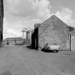
Garlieston, Harbour, Granary
View from WSW showing mill and granary |
26/8/1974 |
Item Level |
|
 |
On-line Digital Images |
SC 446259 |
Papers of Professor John R Hume, economic and industrial historian, Glasgow, Scotland |
Garlieston, Harbour
View from WSW showing granary and pier |
26/8/1974 |
Item Level |
|
 |
On-line Digital Images |
SC 1671806 |
RCAHMS Aerial Photography |
Garlieston, oblique aerial view, taken from the E, centred on the village and harbour. |
22/6/1995 |
Item Level |
|
 |
On-line Digital Images |
SC 1671807 |
RCAHMS Aerial Photography |
Garlieston, oblique aerial view, taken from the ENE, centred on the village and harbour. |
22/6/1995 |
Item Level |
|
 |
On-line Digital Images |
SC 1671808 |
RCAHMS Aerial Photography |
Garlieston, oblique aerial view, taken from the ENE, centred on the village and harbour. |
22/6/1995 |
Item Level |
|
 |
On-line Digital Images |
SC 1671809 |
RCAHMS Aerial Photography |
Garlieston, oblique aerial view, taken from the ENE, centred on the village and harbour. |
22/6/1995 |
Item Level |
|
 |
On-line Digital Images |
SC 1671810 |
RCAHMS Aerial Photography |
Garlieston, oblique aerial view, taken from the NE, centred on the village and harbour. |
22/6/1995 |
Item Level |
|
 |
On-line Digital Images |
SC 2464007 |
Records of the Ordnance Survey, Southampton, Hampshire, England |
Garlieston Harbour, Granary, NX44NE 42, Ordnance Survey index card, Recto |
c. 1958 |
Item Level |
|


