
Pricing Change
New pricing for orders of material from this site will come into place shortly. Charges for supply of digital images, digitisation on demand, prints and licensing will be altered.
Whithorn, 'st Peter Stone'


Cross Incised Stone (Early Medieval)
Site Name Whithorn, 'st Peter Stone'
Classification Cross Incised Stone (Early Medieval)
Canmore ID 63128
Site Number NX43NW 4
NGR NX 4431 3921
Datum OSGB36 - NGR
Permalink http://canmore.org.uk/site/63128


- Council Dumfries And Galloway
- Parish Whithorn
- Former Region Dumfries And Galloway
- Former District Wigtown
- Former County Wigtownshire
NX43NW 4 4431 3921.
(NX 4431 3921) Inscribed Stone (NR) (Site of)
OS 6" map (1957)
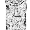
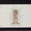
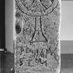
A squared stone pillar, 4' x 1'3" x 9 1/4", bearing an incised cross and inscription which stood at this spot in 1872, was subsequently moved to Whithorn Museum. The inscription, LOCI/PETRI APU/STOLI: "The place of Peter the Apostle", is written in a style belonging to Merovingian Gaul, very rare in Britain, a 7th century date is indicated. Though Collingwood suggests this stone may have been a boundary mark of the precincts of Whithorn (NX44SW 5), Radford defines a locus as a place, possibly a cemetery, with perhaps a small oratory, dedicated to God in honour of a saint. The phrase, and use of the Gaulish alphabet suggest Celtic rather than Saxon connections.
A Mitchell 1873; C A R Radford and G Donaldson 1953; W G Collingwood 1925
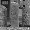
The stone as illustrated, is on display at Whithorn Museum. Nothing is visible at the find spot.
Visited by OS (DWR) 16 January 1973
NX 4502 3940 A desk-based assessment and walkover survey of the fields around Whithorn was undertaken as part of a broader study into the enclosure of the early ecclesiastical site. An early 19th-century estate plan of Mains Farm (RHP 4502), previously un-noted in this context, is of interest for the light it may throw on the original location of the Early Christian Peter Stone (NMRS NX43NW 4).
Mains Farm is depicted on the plan as a sketch elevation. The building, like another to the SE, is a low single-storey structure with a central door, two windows and gable-end hearths. In front of the building, to the S, there is a large featureless rectangle, almost certainly not a building. Given the later documentary evidence for the stone and its association with Mains Farm, it seems likely that the 1812 plan represents our earliest in situ view of the Peter Stone. The revised position of Mains Farm lies significantly to the NW of the location previously estimated.
Full details lodged with the NMRS.
Sponsor: Whithorn Trust.
C Lowe 2001

