
Creag Dalhorrisgle


Cairnfield (Period Unassigned), Hut Circle (Prehistoric)
Site Name Creag Dalhorrisgle
Classification Cairnfield (Period Unassigned), Hut Circle (Prehistoric)
Canmore ID 6289
Site Number NC75NW 81
NGR NC 7121 5571
Datum OSGB36 - NGR
Permalink http://canmore.org.uk/site/6289


- Council Highland
- Parish Farr
- Former Region Highland
- Former District Sutherland
- Former County Sutherland
NC75NW 81 7121 5571.
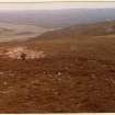
At NC 7121 5571, on the spine of a low ridge among undulating ground, is a peat and heather covered hut circle. Itt measures approximately 9.0m east-west by 7.5m within a wall spread to 2.0m wide and 0.3m in average height. The simple entrance is in the east. Scattered field clearance heaps cover about 2 hectares around the hut, and a further area of clearance heaps also of about 2 hectares lies close by to the south east across the Allt Dalveghouse. No field plots are visible.
Surveyed at 1:10,000.
Visited by OS (J B) 11 December 1978.

