Pricing Change
New pricing for orders of material from this site will come into place shortly. Charges for supply of digital images, digitisation on demand, prints and licensing will be altered.
Drumtroddan
Standing Stone(S) (Prehistoric)
Site Name Drumtroddan
Classification Standing Stone(S) (Prehistoric)
Alternative Name(s) Standing Stone Plantation
Canmore ID 62762
Site Number NX34SE 2
NGR NX 36449 44300
Datum OSGB36 - NGR
Permalink http://canmore.org.uk/site/62762
- Council Dumfries And Galloway
- Parish Mochrum
- Former Region Dumfries And Galloway
- Former District Wigtown
- Former County Wigtownshire
NX34SE 2 36449 44300
(NX 3644 4430) Standing Stones (NR)
OS 6" map (1957)
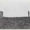
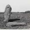
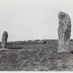
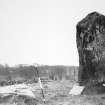
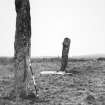
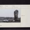
The RCAHMS describes three standing stones, two erect and one fallen, within Standing Stone Plantation. The upright stones, which stand 43' apart, face NE-SW and measure 10'1" x 3' x 1'3" and 10'2" x 4'6" x 1'3". The SW stone is considerably tilted. The third stone lies prostrate between the others, 7' from the SW block and at right angles to the alignment. It measures 9' x 4' x 1'9". The ONB states that there were formerly four stones here. Under guardianship.
Name Book 1848; RCAHMS 1912, visited 1911.
As described. There is no trace and no knowledge of a 4th stone in the area.
Resurveyed at 1/2500.
Visited by OS (I A) 26 January 1973
Publication Account (1986)
Two out of an alignment of three tall standing stones stand clearly visible against the skyline, 3m high, while the central member of the trio lies prostrate.
Information from ‘Exploring Scotland’s Heritage: Dumfries and Galloway’, (1986).


