
Pricing Change
New pricing for orders of material from this site will come into place shortly. Charges for supply of digital images, digitisation on demand, prints and licensing will be altered.
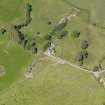
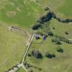
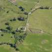
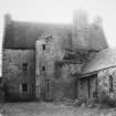
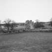
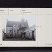
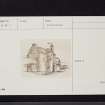
Old Place Of Monreith


Tower House (Medieval)
Site Name Old Place Of Monreith
Classification Tower House (Medieval)
Alternative Name(s) Dowies House; Ballingrene
Canmore ID 62761
Site Number NX34SE 19
NGR NX 38119 43013
Datum OSGB36 - NGR
Permalink http://canmore.org.uk/site/62761


- Council Dumfries And Galloway
- Parish Glasserton
- Former Region Dumfries And Galloway
- Former District Wigtown
- Former County Wigtownshire
NX34SE 19.00 38119 43012
NX34SE 19.01 38129 43033 Coach House
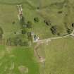
(NX 3811 4303) Dowies or (NAT) Old Place of Monreith (NR)
OS 25" map (1906)
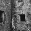
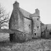
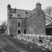
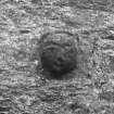
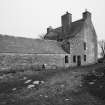
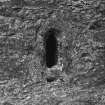
Dowies or the Old Place of Monreith, is described by the SDD as a 3-storey L-shaped house with wheel-stair in the re-entrant angle. They, and the RCAHMS, consider its massive walls and other features indicate a 15th century date. The RCAHMS also states that this was the original home of the Maxwells of Monreith, though Reid considers the original building is NX34SE 18 dating Dowies to c 1600, and adding that when this house was built, the place-name of the original manor, Moure, was moved with the residence, the name Dowies being the recent application. M'Kerlie states that Moure Tower was occupied by the Maxwells until 1683, when Sir Willam Maxwell obtained Myrton Castle (NX34SE 5), and moved there. The Tower became roofless, until the beginning of the 19th century. It was used as a quarry to obtain materials to build a new farm-steading. The battlements and upper storeys were demolished, but as the walls were so thick, it was found easier to re-roof the building and convert it to a farm-house, rather than pull it down.
SDD List, undated; RCAHMS 1912; R C Reid 1948; P H M'Kerlie 1870
Calling it "Dowis and Moor" the ONB adds "This house was formerly the home of Sir Wm Maxwell of Monreith, at which time it was called Moor, but since it has been attached to an adjoining farm called Dowis, it has taken the combined name "Dowis and Moor" (This name was revised on the 2nd edn).
Name Book 1848
Dowies is as described. The building is now deserted and in a ruinous condition.
Visited by OS (IA) 31 January 1973
See also: NX34SE 18 Moure Castle
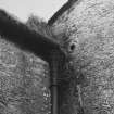
Watching Brief (3 July 2017 - 4 July 2017)
A watching brief was undertaken during ground-breaking work for new drains and replacement down pipes on the exterior of the tower house. Two machine trenches were excavated, one against the building's NW-facing wall and the other against the SW-facing wall. Handmade horseshoe field drains, probably 19th-century in date, were recorded in both trenches and appear to have been used for rainwater drainage. The deposits had been disturbed by modern drainage and path laying operations, and no other significant archaeological features were recorded.
Archive: NRHE (intended)
Funder: Landmark Trust
John Pickin
(Source: DES, Volume 19)
OASIS ID: johnpick1-400133

