
Following the launch of trove.scot in February 2025 we are now planning the retiral of some of our webservices. Canmore will be switched off on 24th June 2025. Information about the closure can be found on the HES website: Retiral of HES web services | Historic Environment Scotland
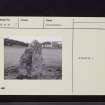
Auchenmalg Bridge


Standing Stone (Prehistoric)
Site Name Auchenmalg Bridge
Classification Standing Stone (Prehistoric)
Alternative Name(s) Auchenmalg; Longforth
Canmore ID 62246
Site Number NX25SW 17
NGR NX 2309 5220
Datum OSGB36 - NGR
Permalink http://canmore.org.uk/site/62246


- Council Dumfries And Galloway
- Parish Old Luce
- Former Region Dumfries And Galloway
- Former District Wigtown
- Former County Wigtownshire
NX25SW 17 2309 5220
(Name: NX 2316 5216) Standing Stone (NR)
OS 6" map (1957)
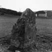
A standing stone, pointed upwards, and measuring 6'9" x 4'3" x 2'10" is situated in the centre of a field 250 yds W of Auchenmalg Bridge. It faces NE-SW.
RCAHMS 1912, visited 1911.
NX 2309 5220. A tapered standing stone measuring 1.2m by 1.0m by 2.2m high.
Surveyed at 1:2500.
Visited by OS (BS) 27 April 1977.

