
Following the launch of trove.scot in February 2025 we are now planning the retiral of some of our webservices. Canmore will be switched off on 24th June 2025. Information about the closure can be found on the HES website: Retiral of HES web services | Historic Environment Scotland
Drumacissock


Military Installation (20th Century)
Site Name Drumacissock
Classification Military Installation (20th Century)
Canmore ID 61473
Site Number NX16NW 18
NGR NX 1096 6777
Datum OSGB36 - NGR
Permalink http://canmore.org.uk/site/61473


- Council Dumfries And Galloway
- Parish Inch
- Former Region Dumfries And Galloway
- Former District Wigtown
- Former County Wigtownshire
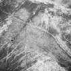
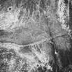
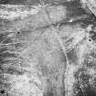
NX16NW 18 1096 6777.
This structure comprises two concentric circles of granite chips, now buried beneath a thin layer of peat, with an overall diameter of 34m.
Visited by RCAHMS (SH) 12 May 1986.
These circles may be connected with the bombing targets NX16NW 110 and NX16NW 111.
Information from RCAHMS (DE), April 1999

