
Pricing Change
New pricing for orders of material from this site will come into place shortly. Charges for supply of digital images, digitisation on demand, prints and licensing will be altered.
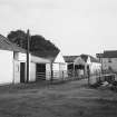
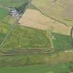
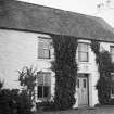
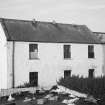
East Galdenoch


Farmhouse (Period Unassigned), Farmstead (Period Unassigned), Outbuilding(S) (Period Unassigned)
Site Name East Galdenoch
Classification Farmhouse (Period Unassigned), Farmstead (Period Unassigned), Outbuilding(S) (Period Unassigned)
Canmore ID 61247
Site Number NX15NW 37
NGR NX 1044 5577
Datum OSGB36 - NGR
Permalink http://canmore.org.uk/site/61247


- Council Dumfries And Galloway
- Parish Stoneykirk
- Former Region Dumfries And Galloway
- Former District Wigtown
- Former County Wigtownshire
Delisted 2000

