
Stranraer, George Street, Castle Of Saint John


Castle (Medieval)
Site Name Stranraer, George Street, Castle Of Saint John
Classification Castle (Medieval)
Alternative Name(s) Stranraer Castle; Castle Prison; The Chapel; Castle Kennedy
Canmore ID 60751
Site Number NX06SE 11
NGR NX 06090 60821
Datum OSGB36 - NGR
Permalink http://canmore.org.uk/site/60751


- Council Dumfries And Galloway
- Parish Stranraer
- Former Region Dumfries And Galloway
- Former District Wigtown
- Former County Wigtownshire
NX06SE 11 06090 60821
(NX 0609 6082) Castle Prison (NR)
OS 1:1056 map (1849)
Castle (Rems. of) (NR)
OS 25" map (1894)
See also NX06SE 25.
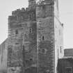
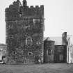
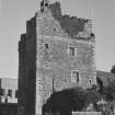
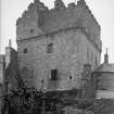
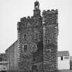
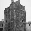
Stranraer Castle, also known as The Chapel and Castle Kennedy, has been a good example of a 16thc L-plan keep; it measures 35 feet by 28 feet - the longer axis being east-west and has a projection of 4ft 9ins, northwards from the north wall at the north-west corner, and this projection is 11ft 9ins wide. In the 17th c the castle was heightened and structurally altered to fit it for use as the town gaol.
D MacGibbon and T Ross 1889; RCAHMS 1912.
This building is generally as described. It is topped by a small cap house and belfry with parapet walk. The remains are in a fair state of repair and the building is used by Stranraer Town Council for various purposes.
Visited by OS (WDJ) 8 February 1963
(Excavation and consolidation work reported by Tabraham and Lewis).
C Tabraham and J Lewis 1979
Three areas were excavated prior to the refurbishment of the castle into a Heritage centre. In the main hall a small inner chamber at the rear of the fireplace was cleared of about 90cm of earth and bird droppings to reveal two stone steps. The wooden floor in front of the chamber was removed and after clearing about 30cm of debris and a modern cement step the original stone slabbing was revealed.
In the main hall a small section (71 by 51cm) of flooring from the centre of the room was cleared and the area below excavated. Pieces of oyster shell and a bird bone were recovered.
In the ground floor entrance area a section (116 by 170cm) was excavated to reveal at a depth of 21cm a floor level and a section of a drainage channel. No finds were recorded.
Excavation record and photographs held in Stranraer Museum.
Sponsor: Wigtown District Council.
E Ritchie 1989.
Non-Guardianship Sites Plan Collection, DC28785- DC28793. 1980 & 1982.
EXTERNAL REFERENCE
Scottish Records Office
Stranraer Proposed conversion of Stranraer Castle to a prinson. Robert Wallace, architect c. 1790-1874 criticises plans he has been sent and describes his own plans for the conversion. The letter accompanied these plans sent to William Leggat.
1820 GD 135/Box 61/26/2
Conversion of the Castle into a Goal [Gaol].
Minutes of Meetings of Commissioners of Supply, Payments, Accounts and receipts.
Contractor: Kenneth Mathieson
1819-1822 GD 135/Box 61/26/1-14
(Undated) information in NMRS.
Publication Account (1986)
Long hidden away and scarcely known, even by the town's inhabitants, this four-storeyed tower is once again prominent in the centre of Stranraer. Its re-emergence in this manner is very fitting, for, from its first construction by the Adairs of Kin hilt in about 1500 until the later 18th century, the 'Castle of Chapel' would have dominated the surrounding community of low, mainly single-storeyed buildings. It was in existence almost a century before the formal creation of Stranraer as a burgh of barony in 1595 (a royal burgh in 1617).
The medieval chapel which gave its name to the tower was a dependency of the parish church ofInch, 4.8km to the east. The late medieval chapel building itself was demolished in the late 17th or early 18th century. The original community of Stranraer proper, on the other hand, lay within the medieval parish of Leswalt, centred 4.8km away to the north-west. Stranraer thus represents a coalescence of two settlements which had grown up on a mutual parish boundary; even today most of the town is divided between the parishes of Inch and Leswalt, the line of the bum and the old parish boundary marked physically by the natural hollow between the castle and George Street.
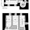
The tower is of conventional late medieval form. Originally it was of three main storeys with a parapet wall-walk and angle-turrets, all open to the skies; the main stair, later diverted at ground-level, is in the projecting wing. The top storey is an addition, and the small round-headed windows (easily distinguished from originallintelled openings) are part of a scheme of modifications carried out in about 1820. At that date the first floor of the tower was converted into a courtroom, three (criminal) cells were formed on the second floor, two (debtors') cells on the third, and an exercise-yard at parapet level.
The building was converted into a police station in 1864, and some prison-cells apparently remained in use until 1907. The building is not yet open to the public. Although altered, it retains much of its original cellular form of construction, the walls containing a network of passages and chambers. The pit-prison was at the rear of the hall fireplace on the fIrst floor reached through a trap-door on the floor above. The 1820 prison-cells still possess many of their awesomely strong and heavy fIttings, and on the walls of the cells and exercise yard there is a lot of graffIti. Such marks speak volumes.
The tower passed into the possession of a branch of the Kennedy family in 1590, and for a time after 1682 became the headquarters of Graham of Claver house, for ever remembered as 'Bloody Claverse' in his role as sheriff of Wigtown.
We know that in 1684 Stranraer had merely 279 inhabitants over the age of 12, but by the end of the 18th century it contained 'many handsome houses and above two thousand inhabitants', most dependent on seasonal shoals of herring in Loch Ryan. This capricious fIsh fmally abandoned the loch in the early 19th century, but the sagging fortunes of the town were revived by its assumption of the Irish steam packet and ferry service.
The earliest surviving municipal building is the former town hall of 1776 at the corner of George Street and Church Street. Although its offIcial duties were done by 1855, it still conveys an impression of civic dignity with its pedimented door-piece rising to a stubby clock tower and spire. According to an 1877 guide 'It is .. like some ladies-not Stranraer ladies, however- very much indebted to paint for its good looks'. Cosmetically treated or not, the faces of many town houses look out over the loch, and its largest Victorian mansion stands close to the harbour. This is the North-West Castle, now a hotel, which was so named and extended by Sir John Ross (1777-1856), famous for his exploration of Canada's Arctic coastline in search of the elusive North West Passage.
Information from ‘Exploring Scotland’s Heritage: Dumfries and Galloway’, (1986).
Publication Account (1995)
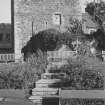
The Castle of St John is probably the sole pre-Reformation remnant in the central area of the town figure 7 &figure 17: E. Although a small chapel which stood nearby gave its name to the settlement on the east side of the burn that runs through Stranraer to Loch Ryan (approximately along the line of the present South Strand Street and North Strand Street), it was the castle that would become the focal point for sixteenth-century settlement in both Chapel and Stranraer. Built around 1520 by the Adair of Kinhilt family, it was to function not only as a home but also as an administrative centre for the Adair territory; and its protective aura, as well as its needs for services and supplies, would have encouraged a clustering of settlement around it.
An L-shaped, fortified house, its original entrance in the north wall gives access to two aulted chambers. An entresol is entered from the wheel-stair, and above this, on the first floor, one large vaulted apartment has two chambers in the thickness of the west wall. Alterations have been made over the centuries, commencing in the seventeenth century when the building was heightened. It was to remain a family home, in the possession of the Adairs, followed by the Kennedys, and then by the Dalrymples of Stair. During the latter's ownership, the castle was used as a billet for Graham of Claverhouse during his offensive against Galloway Covenanters, an indication not only of the Covenanting sympathies of the Dalrymples, but also the relative standing and possible comfort of the castle. After this, major modifications were made. In the nineteenth century the castle's two upper floors became a gaol, with an open parapeted roof for an exercise area. The trappings of the gaol are still in evidence: chains, iron doors and prisoners' graffiti-a sharp reminder of the building's past. By the late nineteenth and early twentieth centuries the castle had become hemmed in by stone buildings and it functioned as a store room throughout much of the twentieth century. Clearance of surrounding buildings, rehabilitation of the fabric and conversion to a museum have brought the castle back to dominance over the surrounding modern settlement.
The Castle of St John is the only Scheduled Ancient Monument in Stranraer. Although further restoration work is unlikely in the foreseeable future, Scheduled Monument Consent (SMC) would be required before more refurbishment or any proposal involving ground disturbance could take place. Recent archaeological work in the two ground floor cellars and the main hall in advance of restoration in 1979, and again in 1989, revealed a number of earlier features. These included stone floors and drains as well as blocked up mural passages and a prison-pit. Beyond removing the original stone floors to reveal features pre-dating the construction of the castle, the potential for further archaeological discoveries is limited. However, more hidden architectural detail could be expected elsewhere in the building.
Information from ‘Historic Stranraer: The Archaeological Implications of Development’ (1995).
Publication Account (1996)
The castle is a four-storeyed L-plan tower of early 16th century date which measures 1 0.8m by 10.1m over walls 1.6m thick. In 1815 it was bought by the town council for £340, and in 1820 the Commissioners of Supply accepted plans by Kenneth Mathieson, a Glasgow architect, to convert it into a 'secure and salutary jail', with cells on the two upper storeys, at an estimated cost of £600. The town council undertook to fit up the first floor as a court-room at a cost of £185, but it is not certain whether this work was carried our. A new prison was built in Lewis Street in 1847, but occasional use was made of the cells in the castle until 1907.
The main external alterations were in the upper storeys, where Mathieson inserted a series of segmental-arched windows in heavy sandstone frames. He also heightened the S wall to replace the original gabled roof with a flat roof, which may have been used as an exercise-area, within a crenellated wall-head. In 1837 the W vault of the ground storey was in use as a lock-up, while there were three criminals' cells on the second floor and two larger debtors' rooms above. All are barrel-vaulted and all but one have fireplaces whose sandstone jambs bear many graffiti. They have heavy iron-plated doors, and their walls were similarly strengthened where they adjoined chimney-flues. Except for the women's cell, which is entered from the main newel-stair, access at each level is from a vaulted N corridor provided with an iron grilled gate.
Information from ‘Tolbooths and Town-Houses: Civic Architecture in Scotland to 1833’ (1996).
Watching Brief (2009 - 2010)
NX 06090 60821 During 2009–10 a series of watching briefs were undertaken in advance of building work connected with the restoration of the Castle of St John. The removal of modern floor slabs on the roof-top exercise yard revealed the original mortar sub-surface and the vaulted roofs of the third floor debtors’ cells constructed in 1820. Removal of modern floor slabs in the first floor hall revealed a set of steps, probably 16th-century in date.
Three external trenches close to the S wall (CSJ 09 B), the N wall (CSJ 09 C) and the NE corner of the building (CSJ 09 D) showed that the area around the castle had been heavily disturbed by service trenches and 20th-century landscaping. The only surviving archaeological deposits were relic traces of the original foundation cut for the castle which were recorded in the N and S trenches.
Archive: RCAHMS (intended). Report: Dumfries and Galloway SMR
John Pickin – Dumfries and Galloway Council
Watching Brief (7 July 2010 - 31 August 2010)
Landscaping works in the vicinity of the Castle of St John, an early 16th century tower-house in Stranraer, revealed traces of the foundation trench surviving in places along the south wall. It had, however, been heavily disturbed along its length by later buried services. Some of these appeared to date back to the mid-nineteenth century, when the structure was converted into the town jail.
Information from Oasis (rathmell1-111512) 28 March 2013

