
Pricing Change
New pricing for orders of material from this site will come into place shortly. Charges for supply of digital images, digitisation on demand, prints and licensing will be altered.
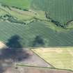
East Reston


Ring Ditch(S) (Period Unassigned)
Site Name East Reston
Classification Ring Ditch(S) (Period Unassigned)
Canmore ID 60228
Site Number NT96SW 39
NGR NT 90448 60918
Datum OSGB36 - NGR
Permalink http://canmore.org.uk/site/60228


- Council Scottish Borders, The
- Parish Coldingham
- Former Region Borders
- Former District Berwickshire
- Former County Berwickshire
NT96SW 39 NT 90448 60918
NT 904 608. Faint cropmarks may indicate three ring-ditches about 350m S of East Reston farmhouse. They are not visible on the ground.
RCAHMS 1980, visited 1979.
Sbc Note
Visibility: This site is visible as a cropmark.
Information from Scottish Borders Council

