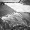
|
Photographs and Off-line Digital Images |
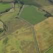
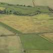
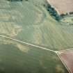
A 29407 |
RCAHMS Aerial Photography |
Oblique aerial view. |
1986 |
Item Level |
|
|
Photographs and Off-line Digital Images |
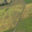
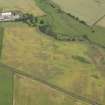
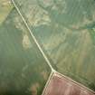
A 29408 |
RCAHMS Aerial Photography |
Oblique aerial view. |
1986 |
Item Level |
|
|
Photographs and Off-line Digital Images |
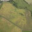
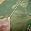
A 29409 |
RCAHMS Aerial Photography |
Oblique aerial view. |
1986 |
Item Level |
|
|
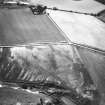
Photographs and Off-line Digital Images |
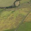
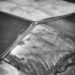
E 40250 CN |
RCAHMS Aerial Photography |
Oblique aerial view centred on the cropmarks of the enclosure and unenclosed settlement with the cropmarks of the rig adjacent, taken from the S. |
3/7/2003 |
Item Level |
|
|
Photographs and Off-line Digital Images |
E 40252 CN |
RCAHMS Aerial Photography |
Oblique aerial view centred on the cropmarks of the enclosure and unenclosed settlement with the cropmarks of the rig adjacent, taken from the ENE. |
3/7/2003 |
Item Level |
|
|
Photographs and Off-line Digital Images |
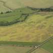
E 40251 CN |
RCAHMS Aerial Photography |
Oblique aerial view centred on the cropmarks of the enclosure and unenclosed settlement, taken from the SE. |
3/7/2003 |
Item Level |
|
 |
On-line Digital Images |
DP 079345 |
RCAHMS Aerial Photography Digital |
Oblique aerial view of the cropmarks of the unenclosed round houses, pits and rig, taken from the N. |
16/7/2009 |
Item Level |
|
 |
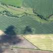
On-line Digital Images |
DP 079346 |
RCAHMS Aerial Photography Digital |
Oblique aerial view of the cropmarks of the barrow, unenclosed round houses, pits and rig, taken from the W. |
16/7/2009 |
Item Level |
|
 |
On-line Digital Images |
DP 079347 |
RCAHMS Aerial Photography Digital |
Oblique aerial view of the cropmarks of the barrow, unenclosed round houses, pits and rig, taken from the WSW. |
16/7/2009 |
Item Level |
|
 |
On-line Digital Images |
DP 079348 |
RCAHMS Aerial Photography Digital |
Oblique aerial view of the cropmarks of the barrow, unenclosed round houses, pits and rig, taken from the SW. |
16/7/2009 |
Item Level |
|
 |
On-line Digital Images |
DP 079351 |
RCAHMS Aerial Photography Digital |
Oblique aerial view of the cropmarks of the barrow, unenclosed round houses, pits and rig, taken from the SW. |
16/7/2009 |
Item Level |
|
 |
On-line Digital Images |
DP 079353 |
RCAHMS Aerial Photography Digital |
Oblique aerial view of the cropmarks of the barrow, unenclosed round houses, pits and rig, taken from the SSE. |
16/7/2009 |
Item Level |
|
 |
On-line Digital Images |
DP 079354 |
RCAHMS Aerial Photography Digital |
Oblique aerial view of the cropmarks of the barrow, unenclosed round houses, pits and rig, taken from the SE. |
16/7/2009 |
Item Level |
|
 |
On-line Digital Images |
DP 215310 |
RCAHMS Aerial Photography Digital |
Oblique aerial view of the cropmarks of the unenclosed settlement and pit alignment, looking NNW. |
18/6/2015 |
Item Level |
|
 |
On-line Digital Images |
SC 1753917 |
RCAHMS Aerial Photography |
Oblique aerial view centred on the cropmarks of the enclosure and unenclosed settlement with the cropmarks of the rig adjacent, taken from the S. |
3/7/2003 |
Item Level |
|
 |
On-line Digital Images |
SC 1753918 |
RCAHMS Aerial Photography |
Oblique aerial view centred on the cropmarks of the enclosure and unenclosed settlement, taken from the SE. |
3/7/2003 |
Item Level |
|
 |
On-line Digital Images |
SC 1753919 |
RCAHMS Aerial Photography |
Oblique aerial view centred on the cropmarks of the enclosure and unenclosed settlement with the cropmarks of the rig adjacent, taken from the ENE. |
3/7/2003 |
Item Level |
|
 |
On-line Digital Images |
SC 1753950 |
RCAHMS Aerial Photography |
Oblique aerial view. |
1986 |
Item Level |
|
 |
On-line Digital Images |
SC 1753951 |
RCAHMS Aerial Photography |
Oblique aerial view. |
1986 |
Item Level |
|
 |
On-line Digital Images |
SC 1753952 |
RCAHMS Aerial Photography |
Oblique aerial view. |
1986 |
Item Level |
|
 |
On-line Digital Images |
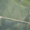
DP 281216 |
Historic Environment Scotland |
Oblique aerial view. |
21/6/2018 |
Item Level |
|
 |
On-line Digital Images |
SC 2458146 |
Records of the Ordnance Survey, Southampton, Hampshire, England |
East Reston, NT96SW 102, Ordnance Survey index card, Recto |
c. 1958 |
Item Level |
|


