 |
On-line Digital Images |
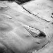
SC 1753463 |
RCAHMS Aerial Photography |
Oblique aerial view centred on the remains of the settlement and farmstead, taken from the NE. |
25/1/2001 |
Item Level |
|
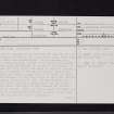 |
On-line Digital Images |
SC 2457867 |
Records of the Ordnance Survey, Southampton, Hampshire, England |
Mire Loch, NT96NW 1, Ordnance Survey index card, page number 1, Recto |
c. 1958 |
Item Level |
|
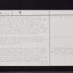 |
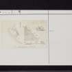
On-line Digital Images |
SC 2457868 |
Records of the Ordnance Survey, Southampton, Hampshire, England |
Mire Loch, NT96NW 1, Ordnance Survey index card, page number 2, Verso |
c. 1958 |
Item Level |
|
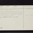 |
On-line Digital Images |
SC 2457869 |
Records of the Ordnance Survey, Southampton, Hampshire, England |
Mire Loch, NT96NW 1, Ordnance Survey index card, page number 3, Recto |
c. 1958 |
Item Level |
|
 |
On-line Digital Images |
SC 2457870 |
Records of the Ordnance Survey, Southampton, Hampshire, England |
Mire Loch, NT96NW 1, Ordnance Survey index card, Recto |
c. 1958 |
Item Level |
|
 |
On-line Digital Images |
SC 2457871 |
Records of the Ordnance Survey, Southampton, Hampshire, England |
Mire Loch, NT96NW 1, Ordnance Survey index card, Recto |
c. 1958 |
Item Level |
|
|
Manuscripts |
MS 36/2 |
Records of the Royal Commission on the Ancient and Historical Monuments of Scotland (RCAHMS), Edinbu |
Journal entitled 'Notes on Berwickshire Monuments'. |
1/8/1908 |
Batch Level |
|
|
All Other |
551 166/1/1 |
Records of the Ordnance Survey, Southampton, Hampshire, England |
Archaeological site card index ('495' cards) |
1947 |
Sub-Group Level |
|


