
Following the launch of trove.scot in February 2025 we are now planning the retiral of some of our webservices. Canmore will be switched off on 24th June 2025. Information about the closure can be found on the HES website: Retiral of HES web services | Historic Environment Scotland
Mordington


Bastle (Medieval), Village (Medieval)
Site Name Mordington
Classification Bastle (Medieval), Village (Medieval)
Alternative Name(s) Mordington, Medieval Village; Mordington House Policies
Canmore ID 60022
Site Number NT95NE 10
NGR NT 951 558
NGR Description NT c. 951 558
Datum OSGB36 - NGR
Permalink http://canmore.org.uk/site/60022


- Council Scottish Borders, The
- Parish Mordington
- Former Region Borders
- Former District Berwickshire
- Former County Berwickshire
NT95NE 10 c. 951 558
See also NT95NE 9.
For (former) associated village (location entered as NT c. 9510 5588), see NT95NE 6.00.
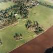
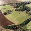
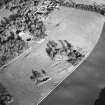
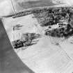
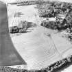
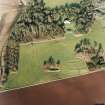
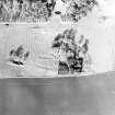
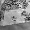
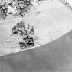
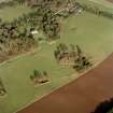
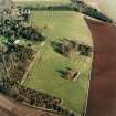
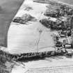
The 'mansio' of Mordington is mentioned in charters at the end of the 11th century and in 1482 'Mordington and its bastel' were burnt by an English army. The remains of the medieval parish church of Mordington (NT95NE 6, at NT 951 558) lie 190m S of the present Mordington House, but there are no other visible remains of settlement.
J Hardy 1879; A C Lawrie 1905; RCAHMS 1980, visited 1979.
Scheduled (with NT95NE 6.00) as 'Mordington, medieval village and church 210m S of Mordington House... the remains of Mordington village, an abandoned later medieval settlement, and the site of Mordington parish church and its associated burial ground.'
Information from Historic Scotland, scheduling document dated 18 January 2010.

