Accessibility

Font Size

100% 150% 200%

Background Colour

Default Contrast
Close Reset

Auchencrow Mains

Unenclosed Settlement (Prehistoric)

Site Name Auchencrow Mains

Classification Unenclosed Settlement (Prehistoric)

Canmore ID 59867

Site Number NT86SE 10

NGR NT 85144 60040

NGR Description Centre

Datum OSGB36 - NGR

Permalink http://canmore.org.uk/site/59867

Ordnance Survey licence number AC0000807262. All rights reserved.
Canmore Disclaimer. © Bluesky International Limited 2025. Public Sector Viewing Terms

Toggle Aerial | View on large map

Digital Images

General oblique aerial view centred on the cropmarks of the settlements and unenclosed settlement, taken from the SE.
General oblique aerial view centred on the cropmarks of the settlements and unenclosed settlement, taken from the SE.Oblique aerial view centred on the cropmarks of the settlements and unenclosed settlement, taken from the SSW.Auchencrow Mains, NT86SE 10, Ordnance Survey index card, page number 1, RectoAuchencrow Mains, NT86SE 10, Ordnance Survey index card, Recto

Administrative Areas

  • Council Scottish Borders, The
  • Parish Coldingham
  • Former Region Borders
  • Former District Berwickshire
  • Former County Berwickshire

Archaeology Notes

NT86SE 10 85114 60036

See also NT86SE 3 and NT86SE 107.

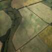
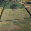
NT 851 600. An unenclosed settlement comprising the sites of at least nine circular timber houses is revealed by cropmarks in an arable field W of Auchencrow Mains.

RCAHMS 1980, flown 1976.

Activities

Note (13 December 2019)

The location, classification and period of this site have been reviewed.

Sbc Note

Visibility: This site is visible as a cropmark.

Information from Scottish Borders Council

References

MyCanmore Image Contributions


Contribute an Image

MyCanmore Text Contributions