
Pricing Change
New pricing for orders of material from this site will come into place shortly. Charges for supply of digital images, digitisation on demand, prints and licensing will be altered.
Westerside


Enclosure (Prehistoric), Farmstead (Period Unassigned), Quarry (Period Unassigned)
Site Name Westerside
Classification Enclosure (Prehistoric), Farmstead (Period Unassigned), Quarry (Period Unassigned)
Alternative Name(s) Moorburn Cottage; Westerside Farm
Canmore ID 59782
Site Number NT86NE 23
NGR NT 888 688
Datum OSGB36 - NGR
Permalink http://canmore.org.uk/site/59782


- Council Scottish Borders, The
- Parish Coldingham
- Former Region Borders
- Former District Berwickshire
- Former County Berwickshire
NT86SE 23 888 688
NT 888 688. On a knoll 200m ENE of Westerside farmhouse there are a number of stony banks which suggest a heart-shaped enclosure and two circular houses; the interior of the enclosure, however, is deeply excavated into the surface of the knoll and the remains may be those of an old old quarry.
The knoll is reported to be the old site of Westerside steading.
RCAHMS 1915; RCAHMS 1980, visited 1980.
Scheduled as 'Moorburn Cottage, settlement 170m NE of... [at] 150m above sea level on a very slight N-facing slope 200m north-east of Waterside Farm.'
Information from Historic Scotland, scheduling document dated 17 February 2009.
Field Visit (May 1911)
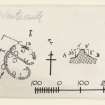
83. Fort, Coldingham Loch.
Some 260 yards east of Westerside farm-steading, on a knoll, at an elevation of 500 feet above sea-level, is another enclosure (fig. 45 [DP 225398]), heart-shaped, measuring some 150 feet by 129 feet, and surrounded by a stony rampart. A low mound bisects into two unequal divisions, each entered from the east, the entrance into the southern or larger division being considerably recessed. In the latter area a large circular foundation with a diameter of 35 feet lies to the south of the entrance, and there are also two or three small hut circles. In the northern area are some three or four hut circles, and another lies outside the enclosure to the south-west. Beyond the enclosure on the north there are indications of foundations.
RCAHMS 1915, visited May 1911.
OS Map: Ber., v. NE. and vi. NW.
Sbc Note
Visibility: This is an upstanding earthwork or monument.
Information from Scottish Borders Council

