 |
On-line Digital Images |
SC 1676731 |
RCAHMS Aerial Photography |
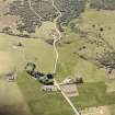
Saint Callan's Church, oblique aerial view, taken from the NE, centred on the church. An area with a manse, small cairns, buildings and various enclosures is visible in the top left half of the photograph. |
23/6/1995 |
Item Level |
|
 |
On-line Digital Images |
SC 1676732 |
RCAHMS Aerial Photography |
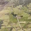
Saint Callan's Church, oblique aerial view, taken from the NE, centred on the church. An area with a manse, small cairns, buildings and various enclosures is visible in the top half of the photograph. |
23/6/1995 |
Item Level |
|
 |
On-line Digital Images |
SC 1692940 |
RCAHMS Aerial Photography |
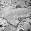
Little Rogart, oblique aerial view, taken from the NW, centred on an area defined as an archaeological landscape. Saint Callan's Church is visible in the upper half of the photograph, and the remains of a structure is shown in the upper left-hand corner. |
13/6/1995 |
Item Level |
|
 |
On-line Digital Images |
SC 1906921 |
Papers of James Sloan Bone, landscape historian, Inverness, Highland, Scotland |
Oblique aerial view of the area around Culdrain, Rogart, East Sutherland, looking SE. |
2000 |
Item Level |
|
 |
On-line Digital Images |
SC 2348663 |
Records of the Ordnance Survey, Southampton, Hampshire, England |
Rogart, St Callan's Church, NC70SW 20, Ordnance Survey index card, page number 1, Recto |
1958 |
Item Level |
|
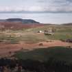 |
On-line Digital Images |
SC 2667589 |
|
General view towards St Callan's church from W |
1996 |
Item Level |
|


