|
Photographs and Off-line Digital Images |
A 12133 |
List C Survey |
View from SW. |
1975 |
Item Level |
|
|
Photographs and Off-line Digital Images |
A 12134 |
List C Survey |
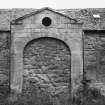
View of blocked in archway. |
1975 |
Item Level |
|
|
Photographs and Off-line Digital Images |
A 12132 |
List C Survey |
General view. |
1975 |
Item Level |
|
|
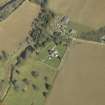
Photographs and Off-line Digital Images |
E 43071 |
RCAHMS Aerial Photography |
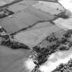
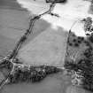
Oblique aerial view centred on the cropmarks of the possible enclosures and linear cropmarks with the church, burial ground, manse, country house, lodge, school, farmhouses, farmsteadings and cottages adjacent, taken from the NE. |
24/7/2003 |
Item Level |
|
|
Photographs and Off-line Digital Images |
E 43072 |
RCAHMS Aerial Photography |
Oblique aerial view centred on the cropmarks of the possible enclosures and linear cropmarks with the church, burial ground, manse, country house, lodge, school, farmhouses, farmsteadings and cottages adjacent, taken from the NNE. |
24/7/2003 |
Item Level |
|
|
Photographs and Off-line Digital Images |
E 43073 |
RCAHMS Aerial Photography |
Oblique aerial view centred on the possible enclosures and linear cropmarks with the church, burial ground, lodge, school, farmhouses, farmsteadings and cottages adjacent, taken from the ENE. |
24/7/2003 |
Item Level |
|
|
Photographs and Off-line Digital Images |
E 43074 |
RCAHMS Aerial Photography |
Oblique aerial view centred on the possible enclosures and linear cropmarks with the church, burial ground, lodge, school, farmhouses, farmsteadings and cottages adjacent, taken from the ENE. |
24/7/2003 |
Item Level |
|
|
Photographs and Off-line Digital Images |
E 43075 |
RCAHMS Aerial Photography |
Oblique aerial view centred on the possible enclosures and linear cropmarks with the church, burial ground, manse, lodge, school, farmhouses, farmsteadings and cottages adjacent, taken from the NE. |
24/7/2003 |
Item Level |
|
|
Photographs and Off-line Digital Images |
E 43076 |
RCAHMS Aerial Photography |
Oblique aerial view centred on the possible enclosures and linear cropmarks with the church, burial ground, manse, lodge, school, farmhouses, farmsteadings and cottages adjacent, taken from the NNE. |
24/7/2003 |
Item Level |
|
|
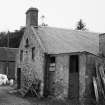
Photographs and Off-line Digital Images |
H 80108 |
Records of Historic Scotland, Edinburgh, Scotland |
View of W range of steading from SE. |
|
Item Level |
|
|
Photographs and Off-line Digital Images |
H 81077 |
Records of Historic Scotland, Edinburgh, Scotland |
View of W range of steading from SW. |
|
Item Level |
|
|
Photographs and Off-line Digital Images |
H 80109 |
Records of Historic Scotland, Edinburgh, Scotland |
View of E range of steading from S. |
|
Item Level |
|
 |
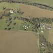
On-line Digital Images |
DP 013341 |
RCAHMS Aerial Photography Digital |
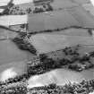
General oblique aerial view centred on the churches and burial-ground with the country house, school, farmhouse and farmsteading adjacent, taken from the SW. |
4/4/2006 |
Item Level |
|
 |
On-line Digital Images |
DP 013342 |
RCAHMS Aerial Photography Digital |
General oblique aerial view centred on the churches and burial-ground with the country house, school, farmhouse and farmsteading adjacent, taken from the SSE. |
4/4/2006 |
Item Level |
|
|
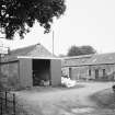
Photographs and Off-line Digital Images |
DP 124788 |
Buildings at Risk Register |
Mid Edrom Steading: U-Plan Court East range, courtyard elevation |
29/9/2011 |
Item Level |
|
|
Photographs and Off-line Digital Images |
DP 124789 |
Buildings at Risk Register |
Mid Edrom Steading: U-Plan Court East wing. |
1/6/2009 |
Item Level |
|
|
Photographs and Off-line Digital Images |
DP 124790 |
Buildings at Risk Register |
Mid Edrom Steading: U-Plan Court West wing. |
1/6/2009 |
Item Level |
|
|
Photographs and Off-line Digital Images |
DP 124791 |
Buildings at Risk Register |
Mid Edrom Steading: U-Plan Court West wing, east elevation. |
1/6/2009 |
Item Level |
|
 |
On-line Digital Images |
SC 1630091 |
List C Survey |
General view. |
1975 |
Item Level |
|
 |
On-line Digital Images |
SC 1630092 |
List C Survey |
View from SW. |
1975 |
Item Level |
|
 |
On-line Digital Images |
SC 1630093 |
List C Survey |
View of blocked in archway. |
1975 |
Item Level |
|
 |
On-line Digital Images |
SC 1752108 |
RCAHMS Aerial Photography |
Oblique aerial view centred on the cropmarks of the possible enclosures and linear cropmarks with the church, burial ground, manse, country house, lodge, school, farmhouses, farmsteadings and cottages adjacent, taken from the NE. |
24/7/2003 |
Item Level |
|
 |
On-line Digital Images |
SC 1752109 |
RCAHMS Aerial Photography |
Oblique aerial view centred on the cropmarks of the possible enclosures and linear cropmarks with the church, burial ground, manse, country house, lodge, school, farmhouses, farmsteadings and cottages adjacent, taken from the NNE. |
24/7/2003 |
Item Level |
|
 |
On-line Digital Images |
SC 1752110 |
RCAHMS Aerial Photography |
Oblique aerial view centred on the possible enclosures and linear cropmarks with the church, burial ground, lodge, school, farmhouses, farmsteadings and cottages adjacent, taken from the ENE. |
24/7/2003 |
Item Level |
|


