Pricing Change
New pricing for orders of material from this site will come into place shortly. Charges for supply of digital images, digitisation on demand, prints and licensing will be altered.
Bunkle Castle
Castle (Medieval)
Site Name Bunkle Castle
Classification Castle (Medieval)
Canmore ID 59699
Site Number NT85NW 2
NGR NT 8052 5965
Datum OSGB36 - NGR
Permalink http://canmore.org.uk/site/59699
- Council Scottish Borders, The
- Parish Bunkle And Preston
- Former Region Borders
- Former District Berwickshire
- Former County Berwickshire
NT85NW 2 8052 5965.
(NT 8052 5965) Bunkle Castle (NR) (Remains of)
OS 6"map, (1957).
Little remained of Bunkle Castle in 1915. It was in a similar condition in 1834, though the NSA adds that 'it seems to have been a place of considerable strength, surrounded by a moat, now greatly filled up. It was once the residence of the Stewarts'.
RCAHMS 1915; New Statistical Account (NSA, A M'Conechy: weritten 1834), 1845.
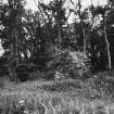
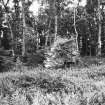
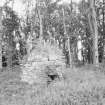
The remains of Bunkle Castle occupy a natural knoll which has been artificially scarped and levelled and has a ditch on the N, W and S sides. All that survives of the castle is a stretch of curtain wall running N-S, 20m long by 1.2m high and up to 1.6m thick, and to the NW a large portion of masonry 4.0m long by 4.0m high and 1.0m thick. The interior is irregular and overgrown and no buildings or walling can be identified. The castle is approached on the NW by a causeway and there is also a possible entrance in the S, indicated by a distinct break in the steep scarp.
Resurveyed at 1:2500.
Visited by OS(IA) 12 December 1972.
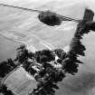
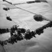
The fragmentary remains of a stone curtain wall stand in the NW quadrant of a roughly circular earthwork measuring up to 57m in diameter over a much spread inner bank. The earthwork has been fashioned from a natural knoll, around the base of which there is a broad ditch accompanied on the NW by slight traces of an outer bank. An entrance on the SE side may be original.
RCAHMS 1980, visited 1979; E Talbot 1975.
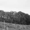
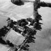
Photographed by the RCAHMS in 1980.
RCAHMS AP catalogue 1980.
Sbc Note
Visibility: This is an upstanding earthwork or monument.
Information from Scottish Borders Council
Dendrochronology
NT 8052 5965 A community excavation at Bunkle Castle in 2019 serendipitously coincided with the SESOD project. The excavation revealed waterlogged remains of a double arc wattle and post structure. Most posts were non-oak species, but one oak post (BKL03) was sampled and analysed for SESOD. The wider assemblage was analysed for the community project’s post-excavation programme by Anne Crone at AOC Archaeology, including a different sample from this same post, so we combined our data for dendro-dating and provenancing this oak post. The combined sequence matched many northern European chronologies at the span AD 1479–1590. The highest correlations were with Germany, an unusual result for a period when most building timber imported into Scotland was Scandinavian. When the post was squared, all sapwood and possibly some heartwood was removed. Allowing for the minimum number of sapwood rings, BKL03 was felled sometime after AD 1600. However, the timber may have been re-used, in which case the post could have been inserted much later. Full details of these and other SESOD results will be given in the project publication. See also the SESOD overview (p6).
Archive: NRHE (intended)
Funder: Historic Environment Scotland
Coralie M Mills – Dendrochronicle
(Source: DES Volume 23)


