
Chirnside, Kirkgate, The Old Church


Church (12th Century), Church (19th Century), Sundial (Post Medieval)
Site Name Chirnside, Kirkgate, The Old Church
Classification Church (12th Century), Church (19th Century), Sundial (Post Medieval)
Alternative Name(s) Chirnside Parish Church
Canmore ID 59653
Site Number NT85NE 23
NGR NT 86964 56030
Datum OSGB36 - NGR
Permalink http://canmore.org.uk/site/59653


First 100 images shown. See the Collections panel (below) for a link to all digital images.
- Council Scottish Borders, The
- Parish Chirnside
- Former Region Borders
- Former District Berwickshire
- Former County Berwickshire
NT85NE 23.00 86964 56030
NT85NE 23.01 86985 56033 Churchyard with Mort-House and War Memorial
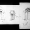
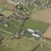
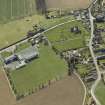
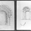
(NT 86964 56030) Chirnside church was extensively restored and altered in 1907. The only original feature remaining is the Norman doorway at the W end of the S wall (SDD undated). A modern stone porch has been erected over this doorway, whose style indicates that the church was probably built in the mid-12th century. The original building was of simple Norman type, oblong on plan, c 78' x 23'. Fragmentary portions of side wells remain, probably indicating the site of a porch. There was also a vaulted W tower, which was taken down in 1750.
RCAHMS 1915, visited 1913.
In normal use.
Visited by OS (JP) 14 December 1972.
Field Visit (19 April 1913)
38. Chirnside Church.
This ancient church is situated upon high ground to the east of the road which passes from north to south through the village of Chirnside. It is now much altered and restored, but the original building appears to have been of the simple Norman type, oblong on plan and measuring some 78 by 23 feet overall. The only feature of interest now remaining is the Norman doorway at the west end of the south wall formed within a projection from the main wall of 9 ½ inches and about 10 feet 2 inches in width. The doorway is lintelled, having a half-round bead worked on the exterior angle, and measuring 2 feet 10 inches between the jambs and 6 feet 10 inches in height. The section of each outer jamb consists of two square recesses containing nook shafts with simply-moulded bases and terminating in cushion caps with square abaci, each supporting one order of a segmental arch. It is to be noted that the abaci which support the inner order are placed at a lower level than those of the outer order. The face of the inner arch is decorated with a chevron, but the soffit is plain, while the outer order has a bead-and-hollow moulding wrought on the angle. The whole is enclosed with a small moulded label having a return at each termination, an unusual feature in Norman work. A modern stone porch has recently been erected over this doorway. Fragmentary portions of side walls remain, probably indicating the position of an older porch. The-church had formerly a vaulted west tower, which was taken down in 1750.
In the Taxatio of 1176 the ‘Ecclesia de Chirnesyd’ is valued at 50 merks. It was annexed as a prebend to the Collegiate Church of Dunbar in 1396. Judging by the style of the south doorway, the church was probably erected about the middle of the 12th century.
Sundial. An old sun-dial has in recent years been erected at the south-west angle of the church. It is square on plan with a half-round base resting on a plain plinth, and terminating in a circular necking surmounted by a ball finial. On the west and south sides of the plain plinth, below the two dial faces, is a motto of incised Roman lettering with the legend HOC AGE DUM LUMEN EST (‘This do whilst there is light’). Incised on the upper dexter angle of the south dial face is the date 1816. Both the lettering and figures appear to be of later date than the dial itself.
RCAHMS 1915, visited 19 April 1913.
See Eccles. Arch., i. p. 322 (illus.); Cast. and Dom. Arch., v. p. 390 (illus.); Ber. Nat. Club, 1890-91, p. 100; Carr's Coldingham, p. 163 (illus.); Antiquaries, xxiv. p. 186 (sun-dial illus.).
OS Map: Ber., xvii. NW.
Sbc Note (15 April 2016)
Visibility: Standing structure or monument.
Information from Scottish Borders Council

