
Pricing Change
New pricing for orders of material from this site will come into place shortly. Charges for supply of digital images, digitisation on demand, prints and licensing will be altered.
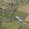
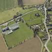
Chirnside, Kirkgate, Dovecot


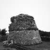
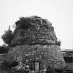
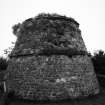
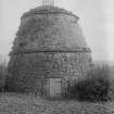
Dovecot (16th Century)
Site Name Chirnside, Kirkgate, Dovecot
Classification Dovecot (16th Century)
Alternative Name(s) Auburn House, Doocot; Ninewells Dovecot; Ninewells House Policies
Canmore ID 59651
Site Number NT85NE 21
NGR NT 86997 56167
Datum OSGB36 - NGR
Permalink http://canmore.org.uk/site/59651


- Council Scottish Borders, The
- Parish Chirnside
- Former Region Borders
- Former District Berwickshire
- Former County Berwickshire
NT85NE 21 86997 56167
For Ninewells House (NT 86396 55747) and associated buildings, see NT85NE 49.00.
(NT 8699 5616) Ninewells Dovecot: 16th century.
(Undated) information from SDD.
Circular beehive type; 60' in circumference at base.
RCAHMS 1915, visited 1908.
A well-preserved beehive-type dovecot.
Visited by OS (JP), 19 December 1972.
Dovecot [NAT]
OS (GIS) MasterMap, February 2011.
Field Visit (6 August 1908)
42. Dovecot near Chirnside Church.
In the corner of a cottage garden about 170 yards north of Chirnside Church is a small dovecot (fig. 17 [SC1172955]) conical in form, divided into two stages by a ledge at 10 feet from the ground. An aperture in the centre of the roof affords means for the ingress and egress of the pigeons. The circumference at base is some 60 feet.
RCAHMS 1915, visited 6 August 1908.
OS Map: Ber., xvii. NW.
Sbc Note
Visibility: This is an upstanding building.
Information from Scottish Borders Council.

